Category:Maps of the American Battlefield Protection Program South Carolina
Jump to navigation
Jump to search

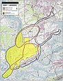
The American Battlefield Protection Program (ABPP) is a US federal government program implemented by the National Park Service of the Department of the Interior with the aim of preserving historic battlefields in the United States. Maps of in this category display battlefield core and study areas, existing and potential national register boundaries.
Media in category "Maps of the American Battlefield Protection Program South Carolina"
The following 11 files are in this category, out of 11 total.
-
 Charleston Harbor I Battlefield South Carolina.jpg 810 × 1,060; 269 KB
-
 Charleston Harbor II Battlefield South Carolina.jpg 810 × 1,060; 396 KB
-
 Fort Sumter I Battlefield South Carolina.jpg 1,060 × 810; 354 KB
-
 Fort Sumter II Battlefield South Carolina.jpg 1,060 × 810; 285 KB
-
 Fort Wagner I Battlefield South Carolina.jpg 1,380 × 1,800; 591 KB
-
 Fort Wagner II Battlefield South Carolina.jpg 1,200 × 1,580; 635 KB
-
 Grimball's Landing Battlefield South Carolina.jpg 1,380 × 1,790; 954 KB
-
 Honey Hill Battlefield South Carolina.jpg 1,060 × 810; 423 KB
-
 Rivers' Bridge Battlefield South Carolina.jpg 1,060 × 810; 436 KB
-
 Secessionville Battlefield South Carolina.jpg 1,390 × 1,820; 814 KB
-
 Simon's Bluff Battlefield South Carolina.jpg 1,470 × 1,900; 869 KB


