Category:Maps of the Algiers Metro
Jump to navigation
Jump to search
Media in category "Maps of the Algiers Metro"
The following 17 files are in this category, out of 17 total.
-
 Algiers Metro - Diagram Line 1 - January 2022 - fr.svg 2,000 × 1,200; 34 KB
-
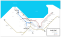
 Algiers Metro - Map Line 1 - January 2022 - en.svg 512 × 512; 53 KB
-
 Algiers Metro - Map Line 1 - January 2022 - fr.svg 512 × 512; 53 KB
-
 Algiers Metro.svg 2,030 × 1,566; 34 KB
-
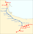
 Map of train-metro-tram of Algiers - January 2022 - fr.svg 2,192 × 1,644; 166 KB
-
 Metro Alger - Plan Ligne - 10 avril 2018.svg 1,535 × 1,024; 56 KB
-
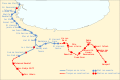
 Metro Alger - Plan Ligne - Avril 2018 ar.svg 1,946 × 1,305; 58 KB
-
 Metro Alger - Plan Ligne - Avril 2018.svg 1,056 × 836; 123 KB
-
 Metro Alger - Plan Ligne - Juillet 2015 (png).png 1,586 × 1,058; 200 KB
-
 Metro Alger - Plan Ligne - Juillet 2015.svg 1,535 × 1,024; 50 KB
-
 Metro Alger - Plan Ligne - Juillet 2017.svg 1,535 × 1,024; 50 KB
-
 Metro Alger - Plan Ligne 1 ar.png 1,015 × 1,021; 101 KB
-
 Metro Alger - Plan Ligne 1.png 1,015 × 1,021; 119 KB
-
 Metro alger ligne 1.png 344 × 396; 24 KB
-
 Metro Algier.gif 3,076 × 1,948; 79 KB
-
 Metro, suburban train and tramway map of Algiers.png 5,192 × 3,203; 7.89 MB
-
 مترو الجزائر.png 5,001 × 3,061; 822 KB


.png)


