Category:Maps of provinces of Laos
Jump to navigation
Jump to search
Subcategories
This category has the following 2 subcategories, out of 2 total.
Media in category "Maps of provinces of Laos"
The following 23 files are in this category, out of 23 total.
-
 Laos Base Map.png 2,909 × 2,153; 327 KB
-
 Laos provinces.png 257 × 282; 14 KB
-
 Map of Attapeu Province, Laos.jpg 903 × 701; 376 KB
-
 Map of Bokeo Province, Laos.jpg 569 × 539; 190 KB
-
 Map of Bolikhamsai Province, Laos.jpg 1,225 × 881; 645 KB
-
 Map of Champasak Province, Laos.jpg 965 × 1,053; 589 KB
-
 Map of Houaphan Province, Laos.jpg 1,142 × 891; 666 KB
-
 Map of Khammouane Province, Laos.jpg 1,383 × 909; 715 KB
-
 Map of Lao PDR provinces numbered.png 257 × 282; 12 KB
-
 Map of Luang Namtha Province, Laos.jpg 799 × 895; 462 KB
-
 Map of Luang Prabang Province, Laos.jpg 1,033 × 1,531; 1.03 MB
-
 Map of Oudomxai Province, Laos.jpg 1,195 × 931; 724 KB
-
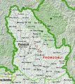 Map of Phongsali Province, Laos.jpg 881 × 987; 548 KB
-
 Map of Saravan Province, Laos.jpg 1,157 × 717; 526 KB
-
 Map of Savannakhet Province, Laos.jpg 1,575 × 955; 868 KB
-
 Map of Sekong Province, Laos.jpg 873 × 861; 466 KB
-
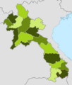
 Map of the provinces of Laos. Updated 2015.png 569 × 633; 65 KB
-
 Map of Vientiane Prefecture, Laos.jpg 715 × 471; 204 KB
-
 Map of Vientiane Province, Laos.jpg 1,347 × 1,145; 973 KB
-
 Map of Xaignabouri Province, Laos.jpg 1,017 × 1,659; 1.02 MB
-
 Map of Xiangkhoang Province, Laos.jpg 1,305 × 1,001; 828 KB
-
 Province of Xaisomboun.png 2,188 × 2,574; 875 KB
-
 Provinces of Laos, shaded.png 510 × 600; 76 KB


