Category:Maps of provinces of Emilia-Romagna
Jump to navigation
Jump to search
- Regions of Italy: Abruzzo · Apulia · Basilicata · Calabria · Campania · Emilia-Romagna · Friuli-Venezia Giulia · Lazio · Liguria · Lombardy · Marche · Molise · Piedmont · Sardinia · Sicily · Trentino-South Tyrol · Tuscany · Umbria · Veneto
Subcategories
This category has the following 6 subcategories, out of 6 total.
F
M
P
R
Media in category "Maps of provinces of Emilia-Romagna"
The following 21 files are in this category, out of 21 total.
-
 Emilia-Romagna Provinces bg.png 1,056 × 816; 52 KB
-
 Emilia-Romagna Provinces.png 1,056 × 816; 35 KB
-
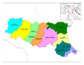
 Emilia Romagna provinces.png 1,144 × 615; 17 KB
-
 Emilia-Romagna Provinces ar.png 776 × 600; 122 KB
-
 Emilia-Romagna Provinces-el-png.png 776 × 600; 122 KB
-
 Emilia-Romagna Provinces-ukr.png 1,056 × 816; 36 KB
-
 Forlicesena mappa.png 750 × 706; 224 KB
-
 Map of Metropolitan city of Bologna (region Emilia-Romagna, Italy).svg 4,800 × 2,530; 146 KB
-
 Map of province of Ferrara (region Emilia-Romagna, Italy).svg 4,800 × 2,530; 146 KB
-
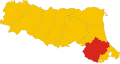 Map of province of Forlì-Cesena (region Emilia-Romagna, Italy).svg 4,800 × 2,530; 146 KB
-
 Map of province of Modena (region Emilia-Romagna, Italy).svg 4,800 × 2,530; 146 KB
-
 Map of province of Parma (region Emilia-Romagna, Italy).svg 4,800 × 2,530; 146 KB
-
 Map of province of Piacenza (region Emilia-Romagna, Italy).svg 4,800 × 2,530; 146 KB
-
 Map of province of Ravenna (region Emilia-Romagna, Italy).svg 4,800 × 2,530; 146 KB
-
 Map of province of Reggio Emilia (region Emilia-Romagna, Italy).svg 4,800 × 2,530; 146 KB
-
 Map of province of Rimini (region Emilia-Romagna, Italy).svg 4,800 × 2,530; 146 KB
-
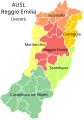 Mappa dell'AUSL di Reggio Emilia.svg 3,540 × 5,026; 93 KB
-
 Ravenna mappa.png 700 × 593; 223 KB
-
 Reggioemila mappa.png 555 × 750; 145 KB
-
 Rimini mappa.png 1,050 × 900; 266 KB
-
 Rimini mappa (2021).png 1,050 × 900; 241 KB


.svg)
.svg)
.svg)
.svg)
.svg)
.svg)
.svg)
.svg)
.svg)


.png)