Category:Maps of proposed countries in Africa
Jump to navigation
Jump to search
Media in category "Maps of proposed countries in Africa"
The following 8 files are in this category, out of 8 total.
-
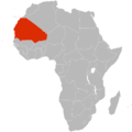 Greater Mauritania.png 2,000 × 2,000; 228 KB
-

-
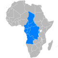 Map of Barthélemy Boganda's proposed United States of Latin Africa.svg 1,000 × 1,000; 188 KB
-
 Map of somaliland border claims.jpg 590 × 504; 118 KB
-
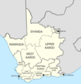 Proposed Map of Cape Republic.png 500 × 523; 104 KB
-
 Union of Arab Republics map.png 2,048 × 2,048; 950 KB
-
 Volkstaat Map.jpg 2,900 × 2,620; 2.11 MB
-
 Volkstaat–VF.svg 1,000 × 765; 202 KB


