Category:Maps of old administrative divisions of Indonesia by User:Milenioscuro
Jump to navigation
Jump to search
Media in category "Maps of old administrative divisions of Indonesia by User:Milenioscuro"
The following 17 files are in this category, out of 17 total.
-
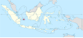
 Bangka in the United States of Indonesia.svg 786 × 361; 676 KB
-
 Banjar in the United States of Indonesia.svg 786 × 361; 676 KB
-
 Belitung in the United States of Indonesia.svg 786 × 361; 676 KB
-
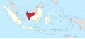
 Central Java in the United States of Indonesia.svg 786 × 361; 676 KB
-
 East Borneo in the United States of Indonesia.svg 786 × 361; 676 KB
-
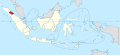
 East Indonesia in the United States of Indonesia.svg 786 × 361; 676 KB
-
 East Java in the United States of Indonesia.svg 786 × 361; 676 KB
-
 East Sumatra in the United States of Indonesia.svg 786 × 361; 676 KB
-
 Great Dayak in the United States of Indonesia.svg 786 × 361; 676 KB
-
 Kotawaringin in the United States of Indonesia.svg 786 × 361; 676 KB
-
 Madura in the United States of Indonesia.svg 786 × 361; 676 KB
-
 Pasundan in the United States of Indonesia.svg 786 × 361; 676 KB
-
 R.I. in the United States of Indonesia.svg 786 × 361; 676 KB
-
 Riau in the United States of Indonesia.svg 786 × 361; 676 KB
-
 South Sumatra in the United States of Indonesia.svg 786 × 361; 676 KB
-
 Southeast Borneo Federation in the United States of Indonesia.svg 786 × 361; 676 KB
-
 West Borneo in the United States of Indonesia.svg 786 × 361; 676 KB


