Category:Maps of neighborhoods in the United States
Jump to navigation
Jump to search
Subcategories
This category has the following 5 subcategories, out of 5 total.
Media in category "Maps of neighborhoods in the United States"
The following 32 files are in this category, out of 32 total.
-
 Map of the Community Areas and 'Sides' of the City of Chicago.svg 612 × 792; 2.9 MB
-
 All-Neighborhoods-Cincinnati.jpg 1,332 × 844; 445 KB
-
 Baltimore neighborhoods map.png 3,090 × 3,500; 2.92 MB
-
 Brooklyn neighborhoods map.png 2,000 × 2,162; 3.27 MB
-
 Chicago community areas map.svg 556 × 578; 165 KB
-
 Chicago neighborhoods map.png 2,000 × 1,599; 406 KB
-
 Chicago neighborhoods outline.svg 1,499 × 1,200; 151 KB
-
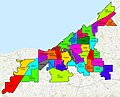
 Cleveland City Neighborhoods with Names.png 2,777 × 2,125; 140 KB
-
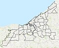
 Cleveland City Neighborhoods.png 2,777 × 2,125; 61 KB
-

-
 Cotswoldcharlotte.png 572 × 422; 94 KB
-
 Forest Glen Park Maryland Location Map.svg 1,596 × 868; 4.79 MB
-
 GermantownBorders-modern.jpg 453 × 508; 51 KB
-
 GlenPark SF.png 625 × 519; 271 KB
-
 Kalamazoo Neighborhoods Numbered.jpg 725 × 599; 57 KB
-
 Neighborhoods - Cleveland.jpg 2,368 × 1,921; 1,002 KB
-
 Neighborhoods of Chicago.JPG 407 × 605; 60 KB
-
 Neighborhoods of Cleveland.jpg 2,368 × 1,921; 1.26 MB
-
 New-York-City-neighborhoods-blank-linewidth.png 1,637 × 2,259; 228 KB
-
 New-York-City-neighborhoods-blank.png 2,652 × 2,582; 481 KB
-
 Omaha neighborhoods.png 1,228 × 617; 103 KB
-
 Pensacola Neighborhoods.PNG 406 × 395; 75 KB
-
 Philadelphia Neighborhood Map.svg 584 × 661; 92 KB
-
 PhilaDistrict.PNG 536 × 575; 21 KB
-
 Pittsburgh Pennsylvania neighborhoods.svg 746 × 600; 293 KB
-
 Queens neighborhoods map.png 2,279 × 3,008; 5.94 MB
-
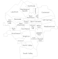
 ShakerHeightsNeighborhoods.png 792 × 455; 26 KB
-
 Sherwoodforest.png 572 × 422; 89 KB
-
 Society Hill Pedestrian Greenway Map.png 1,256 × 1,050; 890 KB
-

-
 Syracuse Neighborhoods Labeled.gif 865 × 891; 25 KB
-
 Upper West Side.jpg 603 × 913; 203 KB


.jpg)


