Category:Maps of municipalities of the Czech Republic
Jump to navigation
Jump to search
Subcategories
This category has the following 180 subcategories, out of 180 total.
A
- Maps of Adamov (7 F)
- Maps of Aš (7 F)
B
- Maps of Bechyně (2 F)
- Maps of Benešov (5 F)
- Maps of Beroun (8 F)
- Maps of Bečov nad Bečvou (3 F)
- Maps of Bílina (5 F)
- Maps of Blansko (2 F)
- Maps of Blatná (4 F)
- Maps of Bohumín (4 F)
- Maps of Boršov nad Vltavou (3 F)
- Maps of Broumov (7 F)
- Maps of Bučovice (3 F)
- Maps of Buštěhrad (1 F)
- Maps of Břeclav (8 F)
C
- Maps of Choceň (3 F)
- Maps of Chotěboř (9 F)
- Maps of Chrastava (6 F)
- Maps of Chrudim (5 F)
D
- Maps of Doksy (1 F)
- Maps of Domažlice (2 F)
- Maps of Dubá (2 F)
- Maps of Duchcov (2 F)
F
- Maps of Frýdek-Místek (11 F)
H
- Maps of Havířov (6 F)
- Maps of Hlinsko (2 F)
- Maps of Hlučín (3 F)
- Maps of Hodonín (3 F)
- Maps of Hořovice (4 F)
- Maps of Hronov (2 F)
J
- Maps of Jablonec nad Nisou (6 F)
- Maps of Jáchymov (10 F)
- Maps of Jaroměřice nad Rokytnou (11 F)
- Maps of Jeseník (3 F)
- Maps of Jevíčko (4 F)
- Maps of Jihlava (12 F)
- Maps of Jindřichův Hradec (3 F)
- Maps of Jílové u Prahy (2 F)
K
- Maps of Kadaň (5 F)
- Maps of Karlštejn (2 F)
- Maps of Karviná (7 F)
- Maps of Kladno (9 F)
- Maps of Klatovy (6 F)
- Maps of Klášterec nad Ohří (2 F)
- Maps of Kolín (7 F)
- Maps of Kouřim (4 F)
- Maps of Kralupy nad Vltavou (13 F)
- Maps of Krnov (4 F)
- Maps of Kroměříž (7 F)
- Maps of Králíky (1 F)
- Maps of Kutná Hora (4 F)
L
- Maps of Lanškroun (1 F)
- Maps of Letovice (1 F)
- Maps of Libochovice (1 F)
- Maps of Libčice nad Vltavou (4 F)
- Maps of Lidice (4 F)
- Maps of Litoměřice (9 F)
- Maps of Lomnice nad Popelkou (1 F)
- Maps of Lovosice (4 F)
- Maps of Lázně Bělohrad (1 F)
M
- Maps of Marianín (2 F)
- Maps of Mimoň (1 F)
- Maps of Mladá Boleslav (3 F)
- Maps of Mníšek pod Brdy (3 F)
- Maps of Moravské Budějovice (6 F)
- Maps of Morkovice-Slížany (1 F)
- Maps of Mělník (6 F)
- Maps of Mšené-lázně (1 F)
N
- Maps of Nechyba (Úžice) (5 F)
- Maps of Neratovice (3 F)
- Maps of Nižbor (2 F)
- Maps of Nové Hrady (3 F)
- Maps of Nový Jičín (1 P, 7 F)
- Maps of Nový Knín (2 F)
- Maps of Nymburk (5 F)
- Maps of Náchod (7 F)
O
P
- Maps of Pacov (1 F)
- Maps of Pelhřimov (3 F)
- Maps of Poděbrady (4 F)
- Maps of Polička (1 F)
- Maps of Postoloprty (1 F)
- Maps of Prachatice (10 F)
- Maps of Prostějov (6 F)
- Maps of Přerov (15 F)
- Maps of Příbram (4 F)
R
- Maps of Rakovník (3 F)
- Maps of Rokycany (1 F)
- Maps of Rudolfov (2 F)
- Maps of Rumburk (8 F)
- Maps of Rychnov nad Kněžnou (2 F)
- Maps of Rýmařov (4 F)
S
- Maps of Sedlec-Prčice (3 F)
- Maps of Sedlčany (1 F)
- Maps of Semily (6 F)
- Maps of Slaný (4 F)
- Maps of Slavkov u Brna (12 F)
- Maps of Sobotka (1 F)
- Maps of Sokolov (7 F)
- Maps of Strakonice (4 F)
- Maps of Studénka (1 F)
- Maps of Stříbro (1 F)
- Maps of Sušice (4 F)
- Maps of Sviadnov (3 F)
- Maps of Svitavy (8 F)
T
- Maps of Tachov (3 F)
- Maps of Teplice (14 F)
- Maps of Trutnov (2 F)
- Maps of Týn nad Vltavou (5 F)
- Maps of Týnec nad Labem (5 F)
- Maps of Třeboň (12 F)
- Maps of Třinec (3 F)
U
- Maps of Uherské Hradiště (10 F)
V
- Maps of Varnsdorf (4 F)
- Maps of Vladislav (4 F)
- Maps of Vodňany (2 F)
- Maps of Volary (13 F)
- Maps of Volyně (1 F)
- Maps of Vrchlabí (4 F)
- Maps of Vsetín (3 F)
- Maps of Vyškov (41 F)
- Maps of Včelná (2 F)
Z
- Maps of Zábřeh (1 F)
Ú
- Maps of Ústí nad Labem (15 F)
- Maps of Ústí nad Orlicí (1 F)
- Maps of Úštěk (5 F)
Č
- Maps of Česká Lípa (5 F)
- Maps of Česká Třebová (2 F)
- Maps of České Velenice (3 F)
- Maps of Český Dub (1 F)
- Maps of Český Krumlov (10 F)
- Maps of Český Těšín (2 F)
Š
- Maps of Šluknov (2 F)
- Maps of Štětí (1 F)
- Maps of Šumperk (2 F)
Ž
- Maps of Žatec (9 F)
- Maps of Ždírec nad Doubravou (1 F)
- Maps of Žďár nad Sázavou (4 F)
Media in category "Maps of municipalities of the Czech Republic"
The following 45 files are in this category, out of 45 total.
-
 Battlefield of Austerlitz - conservation area.png 1,000 × 1,000; 91 KB
-
 Battlefield of Austerlitz - conservation area.svg 1,000 × 1,000; 66 KB
-
 Branov, mapka.jpg 3,888 × 5,184; 6.1 MB
-
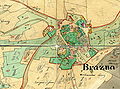 Brazna1839.jpg 2,383 × 1,768; 3.45 MB
-
 ChadimuvMlynBrazna1839.jpg 2,310 × 1,432; 2.43 MB
-
 Czech city Brno.png 200 × 120; 16 KB
-
 CzechRepCitiesTowns.png 930 × 551; 35 KB
-
 Hlučín Urban Heritage Zone.png 1,205 × 863; 545 KB
-
 Holletitz-Karte.jpg 2,587 × 2,133; 1.49 MB
-
 Husinec (P-V), mapa popisných čísel 2010.jpg 5,184 × 3,888; 6.6 MB
-
 Kamenna klementice.svg 326 × 254; 5 KB
-
 Karlovy Vary (CZE) - location map.svg 3,417 × 1,956; 169 KB
-
 Klecánky, u přívozu, mapa Klecan.jpg 5,184 × 3,888; 5.61 MB
-
 KrasnaHora1839.jpg 3,435 × 1,885; 4.13 MB
-
 Loket - Infotafel.JPG 3,648 × 2,736; 3.03 MB
-
 Lípy 1.JPG 574 × 460; 55 KB
-
 Map cz Litvínov kroton.svg 1,052 × 744; 116 KB
-
 Map of all Czech towns and cities.jpg 2,000 × 1,316; 746 KB
-
 Map of all Czech towns and cities2.jpg 2,000 × 1,316; 320 KB
-
 Mapa zaniklé osady Klopoty..jpg 778 × 1,205; 147 KB
-
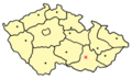
 Mapa1.png 300 × 379; 61 KB
-
 Mikroregion Hustopečsko - mapa hranic.svg 1,620 × 1,483; 53 KB
-
 Municipalities of the Czech Republic which are given town status.png 2,000 × 1,316; 191 KB
-
 MZA, D9, MOR116218300, Kremsier - Zentrum.jpg 3,372 × 2,645; 2.67 MB
-
 MZA, D9, MOR116218300.jpg 5,184 × 6,228; 7.39 MB
-
 MZA, D9, MOR249618260, Wischau - Zentrum.jpg 2,295 × 2,959; 1.59 MB
-
 MZA, D9, MOR249618260.jpg 7,776 × 12,456; 13.47 MB
-
 Obce a země ČR.png 3,845 × 2,222; 719 KB
-
 Openstreetmap Vyškov.PNG 1,004 × 764; 334 KB
-
 Ořech, plán obce (01).jpg 2,839 × 4,287; 1.62 MB
-
 Ořech, plán obce.jpg 4,957 × 3,746; 2.62 MB
-
 Pharus-Plan Franzensbad - btv1b8459802t.jpg 8,620 × 6,528; 9.43 MB
-
 Plzen trol.PNG 1,608 × 974; 97 KB
-
 Plán města Boží Dar.jpg 2,592 × 1,944; 2.51 MB
-
 PopovičkyW.jpg 640 × 916; 106 KB
-
 Prebuz - Haeuserbestand1961.jpg 1,700 × 2,340; 444 KB
-
 Skopirka207112119460 0008.jpg 1,717 × 1,130; 370 KB
-
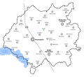
 Towns and cities of the Czech Republic - Středočeský kraj.png 2,000 × 1,316; 191 KB
-
 Vestec, Vestecká, zastávka Vestec, U Klimešů, plán obce.jpg 5,184 × 3,888; 6.02 MB
-
 Volary map.jpg 1,172 × 579; 40 KB
-
 Všeradice, informační tabule, plán.jpg 2,469 × 1,753; 627 KB
-
 Všeradice, informační tabule.jpg 2,349 × 3,193; 978 KB
-
 Zdice, Husova, mapa města.jpg 2,448 × 3,264; 1.38 MB
-
 Čermná nad Orlicí, mapa obce.jpg 3,264 × 2,448; 818 KB
-
 Červená Lhota map, 1906.jpg 596 × 625; 64 KB


,_mapa_popisn%C3%BDch_%C4%8D%C3%ADsel_2010.jpg)

_-_location_map.svg)


.jpg)


