Category:Maps of municipalities of Switzerland to 2019
Jump to navigation
Jump to search
Media in category "Maps of municipalities of Switzerland to 2019"
The following 12 files are in this category, out of 12 total.
-
 Karte Gemeinden des Kantons Aargau 2019.png 2,952 × 2,824; 1.74 MB
-
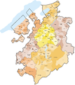
 Karte Gemeinden des Kantons Aargau farbig 2019.png 2,952 × 2,824; 2.28 MB
-
 Karte Gemeinden des Kantons Bern 2019.png 2,952 × 2,448; 1.63 MB
-
 Karte Gemeinden des Kantons Bern farbig 2019.png 2,952 × 2,448; 1.98 MB
-
 Karte Gemeinden des Kantons Freiburg 2017.png 2,952 × 3,308; 1.91 MB
-
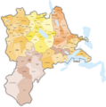
 Karte Gemeinden des Kantons Freiburg farbig 2017.png 2,952 × 3,308; 2.28 MB
-
 Karte Gemeinden des Kantons Graubünden 2019.png 3,836 × 2,751; 1.91 MB
-
 Karte Gemeinden des Kantons Graubünden farbig 2019.png 3,836 × 2,751; 2.06 MB
-
 Karte Gemeinden der Schweiz 2019.01.01.png 4,133 × 2,848; 3.54 MB
-
 Karte Raumplanungsregionen der Schweiz 2019.png 4,133 × 2,848; 3.12 MB
-
 Karte Gemeinden des Kantons Luzern 2016.png 2,952 × 2,972; 1.37 MB
-
 Karte Gemeinden des Kantons Luzern farbig 2016.png 2,952 × 2,972; 1.56 MB


