Category:Maps of municipalities in the district of Moutier
Jump to navigation
Jump to search
Subcategories
This category has only the following subcategory.
Media in category "Maps of municipalities in the district of Moutier"
The following 26 files are in this category, out of 26 total.
-
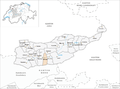
 Karte Gemeinde Belprahon 2007.png 1,476 × 1,095; 351 KB
-
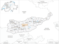
 Karte Gemeinde Bévilard 2007.png 1,476 × 1,095; 352 KB
-
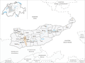
 Karte Gemeinde Champoz 2007.png 1,476 × 1,095; 352 KB
-
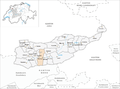
 Karte Gemeinde Châtelat 2007.png 1,476 × 1,095; 351 KB
-
 Karte Gemeinde Corcelles 2007.png 1,476 × 1,095; 351 KB
-
 Karte Gemeinde Court 2007.png 1,476 × 1,095; 352 KB
-
 Karte Gemeinde Crémines 2007.png 1,476 × 1,095; 352 KB
-
 Karte Gemeinde Eschert 2007.png 1,476 × 1,095; 352 KB
-
 Karte Gemeinde Grandval 2007.png 1,476 × 1,095; 352 KB
-
 Karte Gemeinde Loveresse 2007.png 1,476 × 1,095; 352 KB
-
 Karte Gemeinde Malleray 2007.png 1,476 × 1,095; 353 KB
-
 Karte Gemeinde Monible 2007.png 1,476 × 1,095; 351 KB
-
 Karte Gemeinde Moutier 2007.png 1,476 × 1,095; 353 KB
-
 Karte Gemeinde Perrefitte 2007.png 1,476 × 1,095; 352 KB
-
 Karte Gemeinde Pontenet 2007.png 1,476 × 1,095; 351 KB
-
 Karte Gemeinde Rebévelier 2007.png 1,476 × 1,095; 351 KB
-
 Karte Gemeinde Reconvilier 2007.png 1,476 × 1,095; 352 KB
-
 Karte Gemeinde Roches 2007.png 1,476 × 1,095; 351 KB
-
 Karte Gemeinde Saicourt 2007.png 1,476 × 1,095; 352 KB
-
 Karte Gemeinde Saules 2007.png 1,476 × 1,095; 351 KB
-
 Karte Gemeinde Schelten 2007.png 1,476 × 1,095; 350 KB
-
 Karte Gemeinde Seehof 2007.png 1,476 × 1,095; 351 KB
-
 Karte Gemeinde Sornetan 2007.png 1,476 × 1,095; 352 KB
-
 Karte Gemeinde Sorvilier 2007.png 1,476 × 1,095; 352 KB
-
 Karte Gemeinde Souboz 2007.png 1,476 × 1,095; 352 KB
-
 Karte Gemeinde Tavannes 2007.png 1,476 × 1,095; 351 KB


