Category:Maps of land use in Sombrun
Jump to navigation
Jump to search
Media in category "Maps of land use in Sombrun"
The following 3 files are in this category, out of 3 total.
-
 65429-Sombrun-Orthophoto.png 7,015 × 4,960; 7.77 MB
-
 65429-Sombrun-Sols.png 7,015 × 4,960; 3.52 MB
-
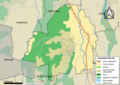
 Sombrun-Carte-Occupation-des-sols.png 960 × 720; 81 KB


