Category:Maps of groups of communes in Lot-et-Garonne to 2015
Jump to navigation
Jump to search
Media in category "Maps of groups of communes in Lot-et-Garonne to 2015"
The following 16 files are in this category, out of 16 total.
-
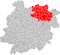
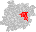
 Localisation EPCI d'Agen en Lot-et-Garonne, France.svg 1,000 × 907; 138 KB
-
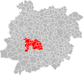
 Localisation EPCI de Penne-d'Agenais en Lot-et-Garonne, France.svg 1,000 × 907; 136 KB
-
-
 Localisation EPCI des coteaux de l'Albret en Lot-et-Garonne, France.svg 1,000 × 907; 137 KB
-

-
 Localisation EPCI du canton de Prayssas en Lot-et-Garonne, France.svg 1,000 × 907; 137 KB
-
 Localisation EPCI du confluent en Lot-et-Garonne, France.svg 1,000 × 907; 137 KB
-
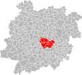
 Localisation EPCI du grand Villeneuvois en Lot-et-Garonne, France.svg 1,000 × 907; 137 KB
-
 Localisation EPCI du Mézinais en Lot-et-Garonne, France.svg 1,000 × 907; 136 KB
-
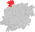 Localisation EPCI du pays de Duras en Lot-et-Garonne, France.svg 1,000 × 907; 137 KB
-
 Localisation EPCI du pays de Lauzun en Lot-et-Garonne, France.svg 1,000 × 907; 137 KB
-
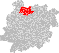
 Localisation EPCI du val d'Albret en Lot-et-Garonne, France.svg 1,000 × 907; 137 KB
-
 Localisation EPCI Fumel communauté en Lot-et-Garonne, France.svg 1,000 × 907; 137 KB
-
 Localisation EPCI Lot et Tolzac en Lot-et-Garonne, France.svg 1,000 × 907; 137 KB
-

-
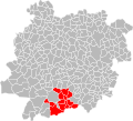
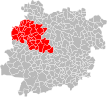 Localisation EPCI Val de Garonne Agglomération en Lot-et-Garonne, France.svg 1,000 × 907; 137 KB


