Category:Maps of gerrymandering in the United States
Jump to navigation
Jump to search
Media in category "Maps of gerrymandering in the United States"
The following 10 files are in this category, out of 10 total.
-
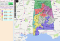 AL Gerrymander.png 877 × 610; 694 KB
-
 ColumbusOhioCongressionalDistricts.svg 1,000 × 800; 704 KB
-
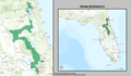 Florida US Congressional District 5 (since 2013).tif 1,738 × 1,012; 2.1 MB
-
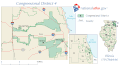 IL04 109.gif 687 × 379; 32 KB
-
 Illinois District 4 2004.png 380 × 379; 13 KB
-
 Illinois's 17th congressional district.gif 635 × 379; 39 KB
-
 North Carolina Congressional Districts 1992-2001.svg 595 × 724; 2.34 MB
-
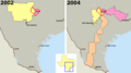
 Texas 30th CD 1991 - 1996.gif 366 × 480; 5 KB
-
 TravisCountyDistricts.png 1,117 × 622; 25 KB
-
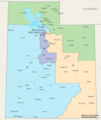 Utah Congressional Districts, 113th Congress.tif 1,350 × 1,600; 497 KB


