Category:Maps of geologic formations of the Signal Hill Group (Canada)
Jump to navigation
Jump to search
Media in category "Maps of geologic formations of the Signal Hill Group (Canada)"
The following 9 files are in this category, out of 9 total.
-
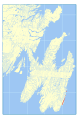
 Bay de Verde Formation map.svg 512 × 786; 26.5 MB
-
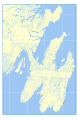
 Blackhead Formation map.svg 512 × 786; 26.47 MB
-
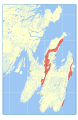
 Cape Ballard Formation map.svg 512 × 786; 26.44 MB
-
 Cappahayden Formation map.svg 512 × 786; 26.44 MB
-
 Cuckold Formation map.svg 512 × 786; 26.47 MB
-
 Ferryland Head Formation map.svg 512 × 786; 26.45 MB
-
 Flat Rock Cove Formation map.svg 512 × 786; 26.45 MB
-
 Gibbett Hill Formation map.svg 512 × 786; 26.82 MB
-
 Quidi Vidi Formation map.svg 512 × 786; 26.48 MB


