Category:Maps of freguesias of Lajes do Pico (Azores)
Jump to navigation
Jump to search
Media in category "Maps of freguesias of Lajes do Pico (Azores)"
The following 12 files are in this category, out of 12 total.
-
 Locator map AZO PIC Calheta de Nesquim.svg 886 × 709; 1.03 MB
-
 Locator map AZO PIC Lajes.svg 886 × 709; 1.06 MB
-
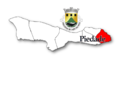
 Locator map AZO PIC Piedade.svg 886 × 709; 1.03 MB
-
 Locator map AZO PIC Ribeiras.svg 886 × 709; 1.04 MB
-
 Locator map AZO PIC Ribeirinha.svg 886 × 709; 1.03 MB
-
 Locator map AZO PIC Sao Joao.svg 886 × 709; 1.03 MB
-
 Pico 01.PNG 960 × 720; 123 KB
-
 Pico 04.PNG 960 × 720; 118 KB
-
 Pico 07.PNG 960 × 720; 114 KB
-
 Pico 10.PNG 960 × 720; 109 KB
-
 Pico 13.PNG 960 × 720; 67 KB
-
 Pico 16.PNG 960 × 720; 111 KB


