Category:Maps of former subdivisions of Rutland
Jump to navigation
Jump to search
Media in category "Maps of former subdivisions of Rutland"
The following 4 files are in this category, out of 4 total.
-
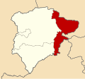 Ketton Rural District, Rutland (1970).svg 612 × 570; 59 KB
-
 Oakham Rural District, Rutland (1970).svg 612 × 570; 59 KB
-
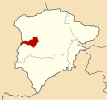 Oakham Urban District, Rutland (1970).svg 612 × 570; 59 KB
-
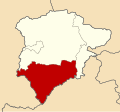 Uppingham Rural District, Rutland (1970).svg 612 × 570; 59 KB
.svg)
.svg)
.svg)
.svg)