Category:Maps of fictional Europe
Jump to navigation
Jump to search
Media in category "Maps of fictional Europe"
The following 32 files are in this category, out of 32 total.
-
 501st Europe 2015.PNG 1,532 × 1,024; 268 KB
-
 Ayla map 1-5.pdf 5,752 × 1,941; 487 KB
-
 Bordúria Map.jpg 1,019 × 855; 160 KB
-
 Carte de Swedenborg.jpg 591 × 601; 193 KB
-
 Ciudad de lyonesse.jpg 557 × 346; 42 KB
-
 Clan ours des cavernes.pdf 7,070 × 3,554; 1.5 MB
-
 Das Neue Europa Mit Dem Dauernden Frieden. Die Unionisierung Mitteleuropas.jpg 8,578 × 6,229; 12.4 MB
-
 Estimated location of fictional city-state of Caprona.jpg 989 × 757; 357 KB
-
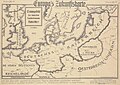
 Europa Zukunftskarte Albert Rymann.jpg 2,667 × 1,875; 3.18 MB
-
 Europa's Zukunftskarte (1915, verso).png 1,355 × 868; 1.8 MB
-
 Europas Zukunftskarte 1915.jpg 693 × 493; 331 KB
-
 European Federation.png 5,412 × 2,997; 929 KB
-
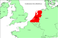
 Fictional Celtic State.svg 215 × 380; 87 KB
-
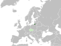 FileKrálovec Region within Europe (fictional).svg 680 × 520; 799 KB
-
 Greater Germany by 1936 majorities.svg 729 × 618; 755 KB
-
 Groot-Nederland in Europa.PNG 1,025 × 673; 41 KB
-
 Groot-Nederland.png 800 × 773; 268 KB
-
 Herenigde Nederlanden.jpg 1,615 × 2,934; 198 KB
-
 HP possible locations of Little Hangleton.JPG 718 × 998; 53 KB
-
 HP Wizarding Schools possible locations.PNG 1,360 × 1,245; 87 KB
-
 Karte Adolf H. Zwei Leben.svg 450 × 456; 304 KB
-
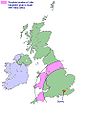
 King and Emperor.PNG 2,100 × 1,525; 134 KB
-
 LocationBorduria.png 250 × 115; 6 KB
-
 LocationSyldavia.png 250 × 115; 6 KB
-
 Map of Arnovia.jpg 1,284 × 1,839; 802 KB
-
 Partition of Switzerland.svg 600 × 660; 183 KB
-

-
 Problème ? Le Rhin, les Alpes, le Danube, l'Euphrate, les mers, les détroits.jpg 8,951 × 7,046; 10.57 MB
-

-
 Schweiz Aufteilung nach Gaddafi Karte.png 650 × 701; 147 KB
-
 Switzerland Gaddafi Map-English.png 650 × 701; 143 KB
-
 Syldavia Map.jpg 1,019 × 855; 161 KB


.png)


.svg)


,_copie_et_traduction_exacte_d%27une_Carte_dont_la_vente_est_autoris%C3%A9e_dans_toute_l%27Allemagne.jpg)


