Category:Maps of ethnic groups in Hungary
Jump to navigation
Jump to search
Subcategories
This category has the following 9 subcategories, out of 9 total.
Media in category "Maps of ethnic groups in Hungary"
The following 25 files are in this category, out of 25 total.
-

-
 8.2a-Hungarian ethnic1495.png 2,112 × 1,379; 244 KB
-
 8.2b-Hungarian ethnic2001.png 2,112 × 1,383; 256 KB
-
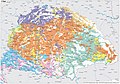
 Ethnic Map of Hungary 1910 with Counties and Towns.png 6,208 × 4,104; 1.53 MB
-
 Ethnic Map of Hungary 1910 with Counties.png 6,208 × 4,104; 1.41 MB
-
 Ethnic Poles minority self-government location.png 2,588 × 1,600; 51 KB
-
 GyulaGombos.png 1,940 × 1,253; 453 KB
-
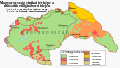
 Hungarian counties by proportion of minority residents.svg 1,052 × 744; 167 KB
-
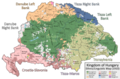
 Hungary 1941 ethnic hu.svg 860 × 490; 339 KB
-
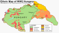 Hungary 1941 ethnic.svg 860 × 490; 475 KB
-
 Hungary roma 2001 (average).png 766 × 482; 54 KB
-
 Hungary roma 2001.PNG 779 × 518; 57 KB
-
 Karpatok.jpg 1,962 × 1,324; 498 KB
-
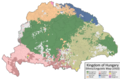
 Kingdom of Hungary - Ethnic Map - 1495.jpg 4,771 × 3,337; 11.96 MB
-
 Kingdom of Hungary - Ethnic Map - 1784.jpg 4,771 × 3,337; 11.87 MB
-
 Magyarország (1941 - 1944) ethnic map.jpg 1,090 × 723; 135 KB
-
 MagyarsOutsideHungary.png 857 × 581; 169 KB
-
 National minorities in Hungary.PNG 635 × 324; 39 KB
-
 RomaniansInHungary1890.png 1,892 × 1,422; 422 KB
-
 Slovensko Porabje.jpg 472 × 455; 23 KB
-
 Transylvania ethnic map 1495.png 659 × 614; 646 KB
-
 Ungarische Bevölkerungsmehrheiten.png 1,409 × 966; 220 KB
-
 Ungarn BV042517718.jpg 11,200 × 7,627; 5.94 MB
-
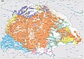
 Zsigmond Batky Karoly Kogutowicz The ethnographical map of Hungary (1918).jpg 5,479 × 7,522; 8.54 MB
-
 Мадяри Європи.png 1,280 × 1,280; 467 KB
%27_(11244908104).jpg)


.png)


_ethnic_map.jpg)


.jpg)
