Category:Maps of ethnic groups in Africa
Jump to navigation
Jump to search
Subcategories
This category has the following 8 subcategories, out of 8 total.
D
E
M
- Maps of African Pygmies (9 F)
S
- Maps of the Somalis (22 F)
T
Y
- Maps of the Yoruba people (11 F)
Media in category "Maps of ethnic groups in Africa"
The following 46 files are in this category, out of 46 total.
-
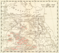
 Ethnographical Outline Map of the Egyptian Sudan, 1891.jpg 2,130 × 2,291; 1.13 MB
-
 23 of 'Africa. Antropologia della stirpe Camitica, etc' (11240959023).jpg 3,618 × 2,634; 1.7 MB
-
 281 of 'Afrika. Eine allgemeine Landeskunde, etc' (11212861045).jpg 1,817 × 2,793; 1.23 MB
-
 287 of 'Afrika. Eine allgemeine Landeskunde, etc' (11211996964).jpg 1,817 × 2,793; 1.36 MB
-

-

-
 A distribution map of Fula people in Africa.jpg 661 × 629; 30 KB
-
 Afarský region.PNG 338 × 407; 9 KB
-
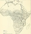
 Africa ethnic groups 1996.jpg 2,446 × 2,819; 4.98 MB
-
 Africa ethnic groups 1996.png 8,651 × 10,315; 154.88 MB
-
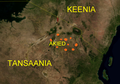 Akie after.png 1,476 × 1,036; 2.26 MB
-
 Akie before.png 1,476 × 1,030; 2.22 MB
-
 Amazigh map.jpg 1,536 × 996; 247 KB
-
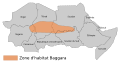 Baggara Arabs Belt-fr.svg 1,149 × 599; 31 KB
-
 Baggara Arabs Belt.svg 1,149 × 599; 24 KB
-
 Batammariba-Schéma de répartition.jpg 564 × 549; 55 KB
-
 Civilisations du mali.png 2,000 × 2,150; 646 KB
-
 D023-Répartition des Pygmées-L1-Ch1.png 1,772 × 1,668; 351 KB
-
 Dispersion du peuple Akan.png 6,300 × 7,000; 2.79 MB
-
 Dispersion du peuple Bedja.png 6,300 × 7,000; 2.54 MB
-
 Dispersion du peuple Berbère.png 6,300 × 7,000; 2.82 MB
-
 Dispersion du peuple Nzerbi.png 6,300 × 7,000; 2.8 MB
-
 Dispersion du peuple Okandé.png 6,300 × 7,000; 2.1 MB
-
 Dispersion du peuple Pygmée.png 6,300 × 7,000; 2.8 MB
-
 Dispertion du peuple Ababdehs.png 6,300 × 7,000; 2.51 MB
-
 Dispertion du peuple Haoussas.png 6,300 × 7,000; 1.71 MB
-
 Dissemination of Monorchy in Africa.svg 1,525 × 1,440; 635 KB
-
 Ethiopia pop 1976.jpg 828 × 711; 136 KB
-
-
 Ethnographische Übersicht der Völker des äquatorialen Ost-Afrika von Dr. Franz Stuhlmann.jpg 19,464 × 14,877; 81.44 MB
-
 Etnias de Sudán del Sur.jpg 2,000 × 1,511; 516 KB
-
 EtniasEtiopía.jpg 1,638 × 1,328; 990 KB
-
 Handbook to the ethnographical collections (1910) (14783017232).jpg 1,872 × 2,060; 443 KB
-

-
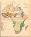
 Map Ethnographic map of Africa 1929 - Touring Club Italiano CART-TRC-28.jpg 6,656 × 6,827; 8.82 MB
-
 Map of South Africa, showing sites of Bushman drawings. Wellcome M0015200.jpg 3,039 × 3,925; 2.44 MB
-
 Marehan (countries habiten by Marehan).png 500 × 500; 137 KB
-
 HJ-1-P16.png 394 × 546; 299 KB
-
 North African location of White Aethiopians Oric Bates 1914.png 968 × 410; 348 KB
-
 Nuerland Map.png 3,507 × 2,480; 465 KB
-
 Siedlungsgebiet der Lega.png 1,149 × 1,096; 2.2 MB
-
 Soninke.gif 428 × 308; 27 KB
-
 Toubou areas in Africa.jpg 341 × 341; 14 KB
-
 Toubou map.svg 1,000 × 1,000; 240 KB
-
 Toubou.png 640 × 578; 778 KB
-
 Народи Африки етнографічна мапа.jpg 938 × 1,027; 149 KB

.jpg)
.jpg)
.jpg)
.jpg)
.jpg)


_(14783017232).jpg)
.jpg)


.png)


