Category:Maps of ecoregions
Jump to navigation
Jump to search
Subcategories
This category has the following 9 subcategories, out of 9 total.
A
- Afrotropical ecoregion maps (133 F)
- Australasian ecoregion maps (67 F)
I
- Indomalayan ecoregion maps (104 F)
M
N
P
- Palearctic ecoregion maps (229 F)
Media in category "Maps of ecoregions"
The following 16 files are in this category, out of 16 total.
-
 800px-Map-Tundra.png 800 × 370; 12 KB
-
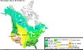 A map of North America's bioregions, improved from the previous.jpg 993 × 596; 121 KB
-
 Region ecologique Californie.gif 609 × 540; 23 KB
-
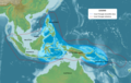 Coral Triangle and countries participating in the Coral Triangle Initiative.png 2,012 × 1,275; 1.45 MB
-
 Ecoregions of the Northeastern United States with counties.png 10,800 × 13,500; 4.18 MB
-
 Ecoregions of the Northeastern United States with waterbodies.png 1,080 × 1,350; 969 KB
-
 Eurasian steppe belt.jpg 2,048 × 1,529; 1.62 MB
-
 Biomes Minnesota.tiff 612 × 699; 1.22 MB
-
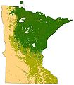 Minnesota Terrestrial Biomes.jpg 611 × 700; 63 KB
-
 Steppe world.png 1,357 × 628; 40 KB
-
 Taiga biome and Caledonian forest ecoregion.svg 1,062 × 531; 6.8 MB
-
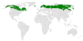 Taiga biome.svg 1,062 × 531; 6.8 MB
-
 Taiga ecoregion.png 3,539 × 1,769; 565 KB
-
 The geography of mammals (1899) (14766041755).jpg 3,082 × 1,786; 505 KB
-
 The geography of mammals (1899) (14785908733).jpg 1,532 × 3,004; 462 KB
-
 Übersichtskarte zur Lage des Korallendreiecks.png 2,000 × 1,094; 2.95 MB


_(14766041755).jpg)
_(14785908733).jpg)
