Category:Maps of districts of Sivas Province
Jump to navigation
Jump to search
Media in category "Maps of districts of Sivas Province"
The following 22 files are in this category, out of 22 total.
-
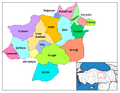
 Sivas (tr).svg 725 × 625; 32 KB
-
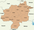
 Sivas districts.png 1,056 × 816; 35 KB
-
 Sivas location districts.png 900 × 800; 85 KB
-
 Navçeyên Sêwasê.png 776 × 600; 115 KB
-
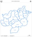 Sivas ilçe sınırları.pdf 7,675 × 8,856; 521 KB
-
 Sivas location Akıncılar.png 900 × 800; 66 KB
-
 Sivas location Altınyayla.png 900 × 800; 66 KB
-
 Sivas location Divriği.png 900 × 800; 66 KB
-
 Sivas location Doğanşar.png 900 × 800; 66 KB
-
 Sivas location Gemerek.png 900 × 800; 65 KB
-
 Sivas location Gölova.png 900 × 800; 66 KB
-
 Sivas location Gürün.png 900 × 800; 65 KB
-
 Sivas location Hafik.png 900 × 800; 66 KB
-
 Sivas location Kangal.png 900 × 800; 66 KB
-
 Sivas location Koyulhisar.png 900 × 800; 65 KB
-
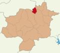
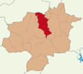
 Sivas location Merkez.png 900 × 800; 66 KB
-
 Sivas location Sarkışla.png 900 × 800; 66 KB
-
 Sivas location Suşehri.png 900 × 800; 66 KB
-
 Sivas location Ulaş.png 900 × 800; 66 KB
-
 Sivas location Yıldızeli.png 900 × 800; 66 KB
-
 Sivas location Zara.png 900 × 800; 66 KB
-
 Sivas location İmranlı.png 900 × 800; 66 KB
.svg)


