Category:Maps of districts of Mpumalanga
Jump to navigation
Jump to search
Media in category "Maps of districts of Mpumalanga"
The following 6 files are in this category, out of 6 total.
-
 Map of Mpumalanga with Ehlanzeni highlighted (2016).svg 768 × 746; 352 KB
-
 Map of South Africa with Ehlanzeni highlighted (2016).svg 809 × 709; 692 KB
-
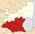 Map of Mpumalanga with Gert Sibande highlighted (2016).svg 768 × 746; 396 KB
-
 Map of South Africa with Gert Sibande highlighted (2016).svg 809 × 709; 703 KB
-
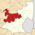 Map of Mpumalanga with Nkangala highlighted (2016).svg 768 × 746; 361 KB
-
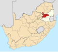 Map of South Africa with Nkangala highlighted (2016).svg 809 × 709; 697 KB
.svg)
.svg)
.svg)
.svg)
.svg)
.svg)