Category:Maps of districts of Meghalaya
Jump to navigation
Jump to search
States of India: Andhra Pradesh · Arunachal Pradesh · Assam · Bihar · Chhattisgarh · Goa · Gujarat · Haryana · Himachal Pradesh · Jharkhand · Karnataka · Kerala · Madhya Pradesh · Maharashtra · Manipur · Meghalaya · Mizoram · Nagaland · Odisha · Punjab · Rajasthan · Sikkim · Tamil Nadu · Telangana · Tripura · Uttar Pradesh · Uttarakhand · West Bengal
Union territories: Dadra and Nagar Haveli and Daman and Diu ·
Former states of India:
Former union territories:
Union territories: Dadra and Nagar Haveli and Daman and Diu ·
Former states of India:
Former union territories:

Subcategories
This category has only the following subcategory.
.
Media in category "Maps of districts of Meghalaya"
The following 16 files are in this category, out of 16 total.
-
 Meghalaya 2011.svg 807 × 434; 156 KB
-
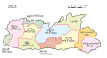
 Meghalaya 2012 as.svg 807 × 434; 155 KB
-
 Meghalaya 2012 ml.svg 807 × 434; 166 KB
-
 Meghalaya 2012-bn.svg 807 × 434; 157 KB
-
 Meghalaya 2012-gu.svg 807 × 434; 157 KB
-
 Meghalaya 2012-hi.svg 807 × 434; 161 KB
-
 Meghalaya 2012-kn.svg 807 × 434; 217 KB
-
 Meghalaya 2012-mr.svg 807 × 434; 162 KB
-
 Meghalaya 2012-pa.svg 807 × 434; 161 KB
-
 Meghalaya 2012-sat.svg 807 × 434; 168 KB
-
 Meghalaya 2012-ta.svg 807 × 434; 162 KB
-
 Meghalaya 2012.svg 807 × 434; 156 KB
-
 Meghalaya 2012.te.svg 807 × 434; 166 KB
-
 Meghalaya districts blank.png 932 × 650; 124 KB
-
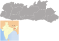
 Meghalaya districts.png 1,231 × 896; 93 KB
-
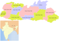 MeghalayaDistrictsMap.png 932 × 650; 138 KB


