Category:Maps of districts of Ankara
Jump to navigation
Jump to search

| NO WIKIDATA ID FOUND! Search for Maps of districts of Ankara on Wikidata | |
| Upload media |
Subcategories
This category has the following 25 subcategories, out of 25 total.
A
- Maps of Akyurt (1 F)
- Maps of Altındağ (1 F)
- Maps of Ayaş (1 F)
B
- Maps of Balâ (1 F)
- Maps of Beypazarı (1 F)
E
- Maps of Elmadağ (1 F)
- Maps of Etimesgut (4 F)
- Maps of Evren (1 F)
G
- Maps of Gölbaşı (1 F)
- Maps of Güdül (1 F)
H
- Maps of Haymana (2 F)
K
- Maps of Kahramankazan (1 F)
- Maps of Kalecik (1 F)
- Maps of Keçiören (1 F)
- Maps of Kızılcahamam (1 F)
M
- Maps of Mamak (1 F)
N
- Maps of Nallıhan (1 F)
P
- Maps of Polatlı (1 F)
- Maps of Pursaklar (1 F)
S
- Maps of Sincan (1 F)
Y
- Maps of Yenimahalle (1 F)
Ç
- Maps of Çamlıdere (1 F)
- Maps of Çankaya (1 F)
- Maps of Çubuk (2 F)
Ş
- Maps of Şereflikoçhisar (1 F)
Media in category "Maps of districts of Ankara"
The following 7 files are in this category, out of 7 total.
-
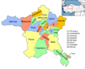
 Ankara (tr).svg 980 × 627; 34 KB
-
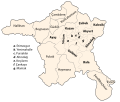
 Ankara districts.png 733 × 600; 166 KB
-
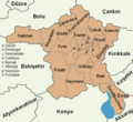
 Ankara haritası (tr).svg 900 × 766; 138 KB
-
 Ankara haritası-arka boş.svg 900 × 766; 49 KB
-
 Ankara haritası-boş.svg 900 × 766; 53 KB
-
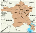 Ankara location districts.svg 1,613 × 1,469; 216 KB
-
 Ankara location districts.png 600 × 550; 86 KB
.svg)

.svg)


