Category:Maps of civil parishes of Blekinge
Jump to navigation
Jump to search
Media in category "Maps of civil parishes of Blekinge"
The following 22 files are in this category, out of 22 total.
-
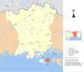 Medelstad Aspö.svg 6,175 × 5,347; 4.34 MB
-
 Medelstad Backaryd.svg 6,175 × 5,347; 4.34 MB
-
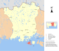
 Medelstad Edestad.svg 6,175 × 5,347; 4.34 MB
-
 Medelstad Eringsboda.svg 6,175 × 5,347; 4.34 MB
-
 Medelstad Fridlevstad.svg 6,175 × 5,347; 4.34 MB
-
 Medelstad Förkärla.svg 6,175 × 5,347; 4.34 MB
-
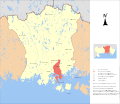
 Medelstad Hasslö.svg 6,175 × 5,347; 4.34 MB
-
 Medelstad Hjortsberga.svg 6,175 × 5,347; 4.34 MB
-
 Medelstad Listerby.svg 6,175 × 5,347; 4.34 MB
-
 Medelstad Nättraby.svg 6,175 × 5,347; 4.34 MB
-
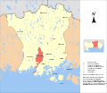
 Medelstad Ronneby.svg 6,175 × 5,347; 4.34 MB
-
 Medelstad Sillhövda.svg 6,175 × 5,347; 4.34 MB
-
 Medelstad Tving.svg 6,175 × 5,347; 4.34 MB
-
 Sockenkarta Blekinge.png 2,262 × 1,263; 74 KB
-
 Östra Augerum.svg 4,490 × 4,408; 373 KB
-
 Östra Jämjö.svg 4,490 × 4,408; 373 KB
-
 Östra Kristianopel.svg 4,490 × 4,408; 373 KB
-
 Östra Lösen.svg 4,490 × 4,408; 373 KB
-
 Östra Ramdala.svg 5,457 × 4,408; 2.43 MB
-
 Östra Rödeby.svg 4,490 × 4,408; 373 KB
-
 Östra Sturkö.svg 4,490 × 4,408; 373 KB
-
 Östra Torhamn.svg 4,490 × 4,408; 373 KB


