Category:Maps of battles of the Thirty Years' War
Jump to navigation
Jump to search
Subcategories
This category has the following 2 subcategories, out of 2 total.
Media in category "Maps of battles of the Thirty Years' War"
The following 56 files are in this category, out of 56 total.
-
 Siege of Pilsen.jpg 4,972 × 3,991; 5.52 MB
-
 Abbildung des K. Schwedischen Lager beÿ Fürt (...) A(nn)o 1632 - btv1b53238753h (1 of 2).jpg 4,920 × 3,526; 4.18 MB
-
 Siege of Nuremberg.jpg 532 × 380; 159 KB
-
 Trexelplan 1632.jpg 2,552 × 3,508; 2.47 MB
-
 Illes Lerins - any 1637.png 567 × 790; 380 KB
-
 Belagerung von Görlitz 1641.jpg 2,213 × 1,616; 1.57 MB
-
 Kempenerheide.jpg 5,089 × 3,453; 3.18 MB
-
 Schwedisches und kaiserliches Lager bei Bernburg 1644.png 4,896 × 4,560; 3.41 MB
-
 Paderborn Grundriss und Belagerung 1646.jpg 1,876 × 2,911; 743 KB
-

-

-
-

-
 Dankaerts-Historis-9340-Nuremberg map.tiff 4,992 × 3,600; 51.45 MB
-
 Battle of Breitenfeld - Annihilation, 17 September 1631.png 1,085 × 843; 74 KB
-
 Battle of Breitenfeld - Initial dispositions, 17 September 1631.png 1,097 × 852; 65 KB
-
 Battle of Breitenfeld - Opening moves, 17 September 1631.png 1,101 × 856; 73 KB
-
 Battle of Breitenfeld - Stopping the attack, 17 September 1631.png 1,097 × 852; 71 KB
-
 Battle of Breitenfeld.jpg 459 × 400; 72 KB
-
 Battle of Lutter-en.svg 993 × 1,112; 77 KB
-
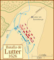 Battle of Lutter-es.svg 993 × 1,112; 195 KB
-
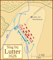 Battle of Lutter-nl.svg 993 × 1,112; 81 KB
-
 Battle of Nördlingen 500.gif 488 × 635; 17 KB
-
 Battle of White Mountain (1620)-NL.svg 532 × 356; 274 KB
-
-
-
 Belagerung und Einnehmun der Stadt und Verstung Manheim Anno 1622.jpg 1,400 × 1,240; 906 KB
-
 Bernburg 1644.jpg 832 × 748; 501 KB
-
 Brindisi, 1618 RCIN 721135.jpg 2,250 × 1,682; 1.62 MB
-
 Dankaerts-Historis-9337.tif 4,404 × 3,528; 44.49 MB
-
 Dankaerts-Historis-9341.tif 4,962 × 3,564; 50.63 MB
-
 Fleurus1622-1 es.svg 781 × 727; 148 KB
-
 Fleurus1622-1 ita.svg 781 × 727; 165 KB
-
 Fleurus1622-2 es.svg 781 × 727; 150 KB
-
 Fleurus1622-2 ita.svg 781 × 727; 167 KB
-
 Fleurus1622-3 es.svg 781 × 727; 168 KB
-
 Fleurus1622-3 ita.svg 781 × 727; 169 KB
-
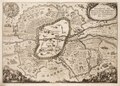
 Treffen1622.jpg 847 × 1,282; 157 KB
-
 Nordlingen1 es.svg 844 × 794; 209 KB
-
 Nordlingen1 ita.svg 844 × 794; 234 KB
-
 Nordlingen2 es.svg 844 × 794; 216 KB
-
 Nordlingen2 ita.svg 844 × 794; 242 KB
-
 Nordlingen3 es.svg 844 × 794; 229 KB
-
 Nordlingen3 ita.svg 844 × 794; 254 KB
-
 Schlacht auf der Kempener Heide 1642.jpg 1,052 × 676; 274 KB
-
 Schlacht bei Mergentheim - Aufstellung Detail.jpg 656 × 442; 506 KB
-
 Schlacht bei Mergentheim - Aufstellung.jpg 1,343 × 919; 1.96 MB
-
 Schlacht bei Mergentheim.png 4,461 × 3,591; 1.92 MB
-
 Siege of Arras (1640) - plan by Melchior Tavernier (II).jpg 2,157 × 1,594; 1.36 MB
-
 Siege of Magdeburg 1631.jpg 910 × 869; 87 KB
-
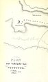
 Spruner-Menke Handatlas 1880 Karte 44 Nebenkarte 9.jpg 1,085 × 1,127; 119 KB
-
 Wittstock1 es.svg 909 × 851; 366 KB
-
 Wittstock1 ita.svg 852 × 797; 167 KB
-
 Wittstock2 es.svg 909 × 851; 389 KB
-
 Wittstock2 ita.svg 852 × 797; 166 KB
-
 Wolfenbüttel Belagerung 1641.jpg 1,181 × 928; 927 KB

_A(nn)o_1632_-_btv1b53238753h_(1_of_2).jpg)


.jpg)
.jpg)
_Schantz_Pfaffenm%C3%BCtz_zwischen_C%C3%B6ln_und_Bon(n)_im_Rhein_erbawen._Anno_1620._;_Abbildung_des_Treffens_zwischen_den_Ka%C3%BFs-_Weinmar-_und_Frantz-_Armee(n)_unter_Comando_dere(n)..._-_btv1b53238778k_(1_of_2).jpg)


-NL.svg)


_-_plan_by_Melchior_Tavernier_(II).jpg)


.jpg)