Category:Maps of Windsor County, Vermont
Jump to navigation
Jump to search
Counties of Vermont: Addison · Bennington · Caledonia · Chittenden · Essex · Franklin · Grand Isle · Lamoille · Orange · Orleans · Rutland · Washington · Windham · Windsor
Wikimedia category | |||||
| Upload media | |||||
| Instance of | |||||
|---|---|---|---|---|---|
| Category combines topics | |||||
| Windsor County | |||||
county in Vermont, United States   | |||||
| Instance of | |||||
| Named after | |||||
| Location | Vermont | ||||
| Capital | |||||
| Inception |
| ||||
| Population |
| ||||
| Area |
| ||||
| official website | |||||
 | |||||
Subcategories
This category has the following 2 subcategories, out of 2 total.
Media in category "Maps of Windsor County, Vermont"
The following 53 files are in this category, out of 53 total.
-
 Detailed map of Wilder, Vermont.png 575 × 425; 31 KB
-

-
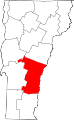 Map of Vermont highlighting Windsor County.svg 627 × 1,020; 17 KB
-
 Map of Windsor County, Vermont LOC 2012586223.jpg 13,654 × 16,501; 36.25 MB
-
 Map of Windsor County, Vermont LOC 2012586223.tif 13,654 × 16,501; 644.6 MB
-
 Map of Windsor County, Vermont LOC 2012586224.tif 13,600 × 16,653; 647.97 MB
-
 Sanborn Fire Insurance Map from Bethel, Windsor County, Vermont. LOC sanborn08907 002.jpg 6,450 × 7,650; 3.98 MB
-
 Sanborn Fire Insurance Map from Bethel, Windsor County, Vermont. LOC sanborn08907 002.tif 6,450 × 7,650; 141.17 MB
-
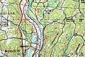 Windor topographic.jpg 600 × 400; 107 KB
-

-
-

-

-

-
-

-

-

-
-

-

-

-

-

-

-

-
-

-

-

-

-
-

-

-

-

-

-

-

-

-

-

-

-

-

-

-

-
-

-

-

-

-
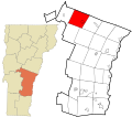
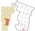
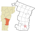
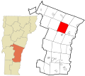
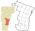
 Windsor County Vermont incorporated and unincorporated areas.svg 835 × 741; 4.75 MB

_(14595232748).jpg)


_highlighted.svg)


_highlighted.svg)

_highlighted.svg)


_highlighted.svg)

_highlighted.svg)


_highlighted.svg)


_highlighted.svg)


_highlighted.svg)


_highlighted.svg)

_highlighted.svg)

