Category:Maps of Western Equatoria State
Jump to navigation
Jump to search
Media in category "Maps of Western Equatoria State"
The following 14 files are in this category, out of 14 total.
-
 SSudan-WE.png 860 × 637; 18 KB
-
 Gharb al-Istiwa'iya.PNG 446 × 350; 41 KB
-
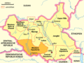 Karte Südsudan Western Equatoria.png 1,500 × 1,133; 192 KB
-
 Map of Western Equatoria State, South Sudan - ZooKeys-285-089-g001.jpeg 1,512 × 1,114; 1.32 MB
-
 Sud Sodan - Estats del Sud Oèst.svg 1,055 × 692; 333 KB
-
 West Equatoria district map overview.svg 744 × 1,052; 76 KB
-
 West Equatoria Sudan map with districts2.svg 744 × 1,052; 155 KB
-
 Western Equatoria Administrative Map-sr.svg 1,055 × 692; 342 KB
-
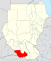
 Western Equatoria in South Sudan (+Kafia Kingi).svg 1,561 × 1,133; 422 KB
-
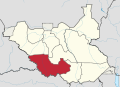
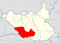
 Western Equatoria in South Sudan.svg 1,561 × 1,133; 422 KB
-
 Western Equatoria Map.svg 1,561 × 1,133; 214 KB
-
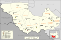
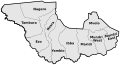 Western Equatoria State Counties.svg 404 × 219; 96 KB
-
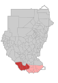
 Locator map Sudan Western Equatoria.png 480 × 568; 125 KB
-
 West Equatoria Sudan map with districts.svg 744 × 1,052; 155 KB


.svg)


