Category:Maps of West Eleri
Jump to navigation
Jump to search
Maps of West Eleri
Media in category "Maps of West Eleri"
The following 19 files are in this category, out of 19 total.
-
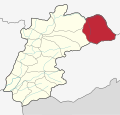
 India Kerala West Eleri adm location map.svg 1,844 × 1,767; 133 KB
-
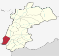
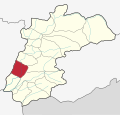 KasaragodWestEleriBheemanady.svg 1,844 × 1,767; 135 KB
-
 KasaragodWestEleriChattamala.svg 1,844 × 1,767; 137 KB
-
 KasaragodWestEleriChennadukkam.svg 1,844 × 1,767; 136 KB
-
 KasaragodWestEleriEachippoyil.svg 1,844 × 1,767; 137 KB
-
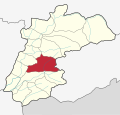
 KasaragodWestEleriEleri.svg 1,844 × 1,767; 136 KB
-
 KasaragodWestEleriKammadam.svg 1,844 × 1,767; 136 KB
-
 KasaragodWestEleriKaruvankayam.svg 1,844 × 1,767; 136 KB
-
 KasaragodWestEleriKottamala.svg 1,844 × 1,767; 136 KB
-
 KasaragodWestEleriKunnumkai.svg 1,844 × 1,767; 143 KB
-
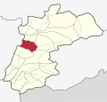
 KasaragodWestEleriMandapam.svg 1,844 × 1,767; 135 KB
-
 KasaragodWestEleriMoukodu.svg 1,844 × 1,767; 136 KB
-
 KasaragodWestEleriNarkilakkad.svg 1,844 × 1,767; 135 KB
-
 KasaragodWestEleriNattakkal.svg 1,844 × 1,767; 136 KB
-
 KasaragodWestEleriParamba.svg 1,844 × 1,767; 135 KB
-
 KasaragodWestEleriParappachal.svg 1,844 × 1,767; 135 KB
-
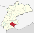
 KasaragodWestEleriPerumbatta.svg 1,844 × 1,767; 137 KB
-
 KasaragodWestEleriPlachikkara.svg 1,844 × 1,767; 136 KB
-
 KasaragodWestEleriPunnakunnu.svg 1,844 × 1,767; 136 KB


