Category:Maps of Weimar by Braun & Hogenberg
Jump to navigation
Jump to search
Media in category "Maps of Weimar by Braun & Hogenberg"
The following 13 files are in this category, out of 13 total.
-
 Weimar 1569.jpg 2,620 × 1,948; 3.31 MB
-
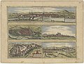
 Weimar-1588-Hogenberg.jpg 3,176 × 2,334; 1.37 MB
-
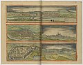 Beschreibung der Städt der Welt - Braun & Hogenberg - btv1b52512111k (089 of 378).jpg 8,166 × 6,320; 7.71 MB
-

-

-
 Frans Hogenberg, Weimaria (FL43890291 3941418).jpg 13,283 × 9,912; 190.55 MB
-
 Franz Hogenberg, „Wolfscher Plan“, Köln 1581, Ausschnitt.jpg 650 × 622; 194 KB
-
 Braun Weimar HAAB.jpg 1,110 × 281; 231 KB
-
 Braun Weimar UBHD.jpg 2,001 × 532; 624 KB
-
-
 Weinmar - btv1b531789984 (1 of 2).jpg 6,508 × 4,968; 5.75 MB
-

-
 Vrbivm praecipvarvm totivs Mvndi liber tertivs 1616 (34065014).jpg 14,337 × 10,062; 27.04 MB


.jpg)


.jpg)

.jpg)
.jpg)
.jpg)
.jpg)