Category:Maps of Vyborg
Jump to navigation
Jump to search
Wikimedia category | |||||
| Upload media | |||||
| Instance of | |||||
|---|---|---|---|---|---|
| Category combines topics | |||||
| Vyborg | |||||
city in Leningrad Oblast, Russia     | |||||
| Instance of | |||||
| Location |
| ||||
| Inception |
| ||||
| Significant event |
| ||||
| Population |
| ||||
| Area |
| ||||
| Elevation above sea level |
| ||||
| Different from | |||||
| official website | |||||
 | |||||
Media in category "Maps of Vyborg"
The following 60 files are in this category, out of 60 total.
-
 9319. Vyborg-City of Military Glory.jpg 3,456 × 4,608; 8.54 MB
-
 9326. Viipuri-sotilaallisen loiston kaupunki.jpg 3,456 × 4,608; 5.16 MB
-
 AFRE Vyborg.jpg 2,718 × 2,373; 1.13 MB
-
 Annenkrone Vyborg.JPG 670 × 459; 94 KB
-
 Communication de Viborg à Kexholm - btv1b55003022f.jpg 8,801 × 5,120; 2.82 MB
-
 Dostověrnaâ vsego Vyborhskogo uězdu novaâ karta... 3 mìlʺ - btv1b8439905v.jpg 12,246 × 8,766; 16.08 MB
-
 General plan of Vyborg municipality 01.jpg 3,283 × 3,253; 2.5 MB
-
 General plan of Vyborg municipality 02.jpg 3,579 × 3,469; 2.19 MB
-
 General plan of Vyborg municipality 03.jpg 3,424 × 3,397; 1.89 MB
-
 General plan of Vyborg municipality 04.jpg 3,356 × 3,513; 4.98 MB
-
 General plan of Vyborg municipality 05.jpg 1,347 × 1,509; 845 KB
-
 General plan of Vyborg municipality 06.jpg 3,424 × 3,397; 1.68 MB
-

-
 Karta över Finska viken med södra Finland, Estland samt Ingermanland och Ladoga, från 1742 - Skoklosters slott - 97952.tif 4,301 × 3,571, 2 pages; 43.96 MB
-
 Karta över Viborg under tidigt 1900-tal.png 782 × 1,150; 129 KB
-
 Map of Viborg.png 2,225 × 1,266; 2.52 MB
-
 Nagaev Atlas vsego Vyborg-Koivisto.jpg 3,072 × 2,048; 3.39 MB
-
 Okrestnosti Vyborga karta.jpg 1,996 × 2,791; 728 KB
-
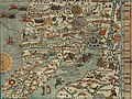 Olaus Magnus' Map of Scandinavia 1539, Section F, Moscovie.jpg 1,665 × 1,243; 507 KB
-
 Plan av Viborgs fästning och stad. 1600-talet.jpg 13,206 × 8,180; 12.19 MB
-
 Plan von Monrepos.jpg 3,719 × 2,989; 9.42 MB
-
 Plan Wyborga 1802.jpeg 17,160 × 11,022; 16.36 MB
-

-

-

-
 Saymensky kanal (1) 1905.jpg 3,468 × 11,997; 23.11 MB
-
 Suomenvedenpohja osm 20100602.svg 864 × 795; 481 KB
-
 Suur-Merijoki map 02.jpg 791 × 1,024; 176 KB
-
 Suur-Merijoki map.jpg 1,024 × 868; 220 KB
-
 UG EZY wikimeetup in Vyborg 2021-01-02 - IMG 9107.jpg 4,032 × 3,024; 1.32 MB
-
 Venäläinen Viipurin piirikunnan kartta 1797.jpg 14,029 × 8,505; 8.37 MB
-
 Viborg Tram Map.JPG 782 × 644; 369 KB
-
 Viipuri Viborg 1930 map legend.jpg 8,456 × 4,872; 7.74 MB
-
 Viipuri Viborg 1930 map.jpg 8,448 × 4,888; 10.5 MB
-
 Viipurin asemakaava. Andreas Streng, Oxehufwud, O. A. 1630s.tif 3,543 × 2,501; 25.37 MB
-
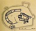
 Viipurin kaupunginmuurin pohjapiirros 1750.png 1,193 × 967; 185 KB
-
 Viipurin kaupunki sijainti.svg 2,000 × 2,400; 2.57 MB
-
 Viipurin linna.jpg 244 × 212; 13 KB
-
 Viipurin pamaus.jpg 458 × 368; 143 KB
-
 Vyborg 1905.jpg 5,068 × 8,498; 19.26 MB
-
 Vyborg map of 1644.jpg 10,678 × 5,447; 6.69 MB
-
 Vyborg siege diagram-ru.gif 884 × 597; 141 KB
-
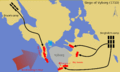 Vyborg siege diagram.gif 1,632 × 976; 93 KB
-
 Vyborg.gif 322 × 238; 15 KB
-
 Vyborgskoe GP.png 2,000 × 1,972; 169 KB
-
 Vyborgsky District, Leningrad Oblast, Russia - panoramio (21).jpg 2,560 × 1,920; 1.36 MB
-
 Wiborg 1839.jpg 7,176 × 5,520; 23.85 MB
-
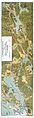
 Wiipurin ympäristön kartta osa 1.tif 5,615 × 4,512; 73.12 MB
-
 Wiipurin ympäristön kartta osa 2.tif 5,927 × 4,380; 74.91 MB
-
 Wijbårgh stadhz affritningh. Andreas Streng. 1640.jpg 6,661 × 4,898; 2.31 MB
-
 Wyborgplan.png 800 × 473; 364 KB
-
 Выборг (53).JPG 3,264 × 2,176; 3.39 MB
-
 Выборг - panoramio (44).jpg 4,608 × 3,072; 6.15 MB
-
 Выборгский уезд.jpg 4,625 × 3,653; 12.02 MB
-
 Карта к статье «Выборг». Военная энциклопедия Сытина (Санкт-Петербург, 1911-1915).jpg 2,861 × 1,896; 1.36 MB
-
 План выборгских укреплений.JPG 600 × 411; 60 KB
-
 План Выборгской крепости, 1812 год.jpg 9,270 × 5,120; 4.07 MB
-
 План Выборгской крепости, 1851 год.jpg 7,474 × 5,120; 4.02 MB
-
 План Выборгской крепости, 1854 год.jpg 7,980 × 5,120; 4.61 MB
-
 Планы городов из Полного собрания законов Российской империи 083.jpg 2,997 × 2,401; 2 MB


.jpg)


_(14762017671).jpg)


.jpg)


.JPG)
.jpg)

.jpg)


_1905.jpg)