Category:Maps of Valverde del Camino
Jump to navigation
Jump to search
Municipalities of the province of Huelva: Aljaraque · Almonaster la Real · Almonte · Alosno · Aracena · Aroche · Ayamonte · Berrocal · Bollullos Par del Condado · Cabezas Rubias · Cala · Campofrío · Cañaveral de León · Cartaya · Cortegana · Cortelazor · Cumbres de San Bartolomé · El Campillo · El Granado · Encinasola · Escacena del Campo · Galaroza · Gibraleón · Higuera de la Sierra · Huelva · Isla Cristina · Jabugo · La Palma del Condado · Lepe · Los Marines · Minas de Riotinto · Moguer · Nerva · Niebla · Palos de la Frontera · Punta Umbría · Rosal de la Frontera · San Bartolomé de la Torre · San Juan del Puerto · San Silvestre de Guzmán · Sanlúcar de Guadiana · Valdelarco · Valverde del Camino · Villalba del Alcor · Villanueva de las Cruces · Villanueva de los Castillejos · Villarrasa · Zalamea la Real · Zufre ·
Media in category "Maps of Valverde del Camino"
The following 6 files are in this category, out of 6 total.
-
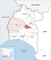 Karte Gemeinde Valverde del Camino 2022.png 2,500 × 2,924; 925 KB
-
 Map of Valverde del Camino (Huelva).png 334 × 427; 23 KB
-
 MTN25-0960c3-1981-Valverde del Camino.jpg 7,726 × 5,387; 7.25 MB
-
 MTN25-0960c3-2003-Valverde del Camino.jpg 7,726 × 5,434; 10.2 MB
-
 MTN25-0960c3-2012-Valverde del Camino.jpg 7,468 × 5,180; 11.19 MB
-
 MTN25-0960c3-2013-Valverde del Camino.jpg 7,579 × 5,133; 22.53 MB

.png)


