Category:Maps of Traînou
Jump to navigation
Jump to search
Wikimedia category | |||||
| Upload media | |||||
| Instance of | |||||
|---|---|---|---|---|---|
| Category combines topics | |||||
| Traînou | |||||
commune in Loiret, France  .svg)  | |||||
| Instance of | |||||
| Location |
| ||||
| Population |
| ||||
| Area |
| ||||
| official website | |||||
 | |||||
Media in category "Maps of Traînou"
The following 13 files are in this category, out of 13 total.
-
 45 Znieff 313.jpg 5,457 × 3,543; 1.5 MB
-
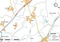
 45-Trainou-Routes.png 5,457 × 3,543; 3.39 MB
-
 45327-Traînou-argile.png 3,057 × 2,480; 2.78 MB
-
 45327-Traînou-Arron.png 7,015 × 4,960; 3.96 MB
-
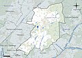
 45327-Traînou-Canton.png 7,015 × 4,960; 4.02 MB
-
 45327-Traînou-Cours eau.jpg 3,507 × 2,480; 485 KB
-
 45327-Traînou-EPCI.png 7,015 × 4,960; 4.02 MB
-
 45327-Traînou-Hydro.jpeg 5,846 × 4,133; 2.12 MB
-
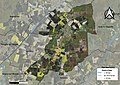 45327-Traînou-Orthophoto.jpeg 10,559 × 7,440; 11.35 MB
-
 45327-Traînou-PETR.png 7,015 × 4,960; 3.95 MB
-
 45327-Traînou-Sols.png 3,519 × 2,480; 2.72 MB
-
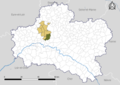
 Map commune FR insee code 45327.png 756 × 605; 72 KB
-
 Secteur-college-La-Forêt.png 3,519 × 2,480; 1.82 MB


