Category:Maps of Tourém
Jump to navigation
Jump to search
Media in category "Maps of Tourém"
The following 14 files are in this category, out of 14 total.
-
 Freguesia de Tourém.svg 1,909 × 1,600; 461 KB
-
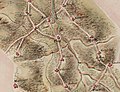
 Coutomixto4.jpg 1,426 × 1,438; 176 KB
-
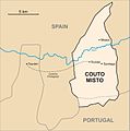
 Mapa do Couto Misto.png 1,073 × 967; 56 KB
-
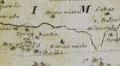 Couto Misto no mapa do bispado de Ourense de Cornide (1763).png 289 × 160; 75 KB
-
-
 Couto Misto no mapa do partido de Ourense de Juan Quintana (1807).jpg 1,498 × 1,419; 2.66 MB
-
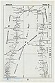
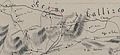 Carta topográfica do Julgado de Montalegre 1836 Fidencio Bourman (Couto misto).jpg 2,348 × 1,072; 920 KB
-
 Carta topográfica do Julgado de Montalegre 1836 Fidencio Bourman.jpg 4,776 × 3,361; 4.33 MB
-

-
 Couto Misto na Carta Geométrica de Galiza (1845).jpg 1,663 × 1,032; 1.4 MB
-

-
 Couto Misto no mapa de José de Castro López (1863).jpg 2,095 × 2,070; 3.9 MB
-
 Tourém no mapa de José de Castro López (1863).jpg 2,248 × 2,188; 4.09 MB
-
 Fronteira de Tourém coa Galiza.jpg 5,155 × 7,742; 8.71 MB


.png)
.jpg)
.jpg)
.jpg)

.jpg)
.jpg)

.jpg)
.jpg)
