Category:Maps of Thrace
Jump to navigation
Jump to search
Subcategories
This category has the following 3 subcategories, out of 3 total.
M
O
- Old maps of Thrace (27 F)
Media in category "Maps of Thrace"
The following 29 files are in this category, out of 29 total.
-
 Arda Mariza-es.svg 956 × 672; 22.49 MB
-
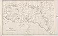
 Balkan-Halbinsel - bearbeitet von B. Domann - btv1b53121550d (2 of 2).jpg 7,218 × 8,684; 10.5 MB
-

-

-
 EstThraceWithinThrace.png 338 × 274; 38 KB
-
 Frontier defined by the Bulgarian–Ottoman Convention of 1915.png 1,500 × 3,000; 586 KB
-
 Hellenic Thrace Map El.jpg 1,974 × 1,532; 253 KB
-
 Hellenic Thrace Map En.png 1,974 × 1,532; 295 KB
-

-
 Map-trakija.gif 501 × 500; 33 KB
-
 NorthThraceWithinThrace.png 338 × 274; 37 KB
-
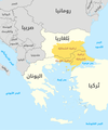
 Thrace and present-day state borderlines zh.png 593 × 710; 151 KB
-
 Thrace and present-day state borderlines-ar.png 593 × 710; 140 KB
-
 Thrace and present-day state borderlines-bg.png 3,128 × 3,739; 963 KB
-
 Thrace and present-day state borderlines.png 593 × 710; 142 KB
-
 Thrace modern state boundaries.png 201 × 201; 2 KB
-
 Thrace region.jpg 875 × 579; 183 KB
-
 Thracia SPQR.png 800 × 548; 28 KB
-
 Thraki bg.gif 536 × 310; 18 KB
-
 TraciaTopográfica.svg 956 × 672; 22.45 MB
-
 WestThraceWithinThrace.png 338 × 274; 37 KB
-
 Xenophon - Grant (1871) - Route of the Ten Thousand map.jpg 1,025 × 636; 84 KB
-
 Χάρτης μεταβυζαντινών ναών στην περιοχή Μεταξάδων EN 2.png 1,920 × 1,080; 1.34 MB
-
 Χάρτης της Δυτικής Θράκης.png 4,326 × 2,729; 2.25 MB
-
 Източна Тракия на картата на Мармара, Турция.png 776 × 600; 94 KB
-
 Карта современной Фракии.png 201 × 201; 3 KB
-
 Тракија.jpg 600 × 600; 90 KB
-
 Тракия.PNG 380 × 334; 9 KB
-
 트라키아 지역 그리고 오늘날의 국경.png 593 × 710; 141 KB

.jpg)


_-_Route_of_the_Ten_Thousand_map.jpg)


