Category:Maps of Teotihuacán
Jump to navigation
Jump to search
Media in category "Maps of Teotihuacán"
The following 16 files are in this category, out of 16 total.
-
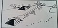
 128 of 'A Popular History of the Mexican People' (11106187933).jpg 610 × 1,302; 168 KB
-

-
 561 of 'A Popular History of the Mexican People' (11106360253).jpg 597 × 1,290; 160 KB
-
 Conjunto Teotihuacan Detallado.JPG 936 × 456; 160 KB
-
 Descripción del conjunto teotihuacan.jpg 1,006 × 566; 129 KB
-
 ES-Teotihuacanos.png 1,031 × 757; 1.02 MB
-
 Location Teotihuacan.png 278 × 183; 16 KB
-
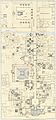
 Plan of Ruins of Pyramids.jpg 534 × 698; 190 KB
-
 Teotihuacan completo.jpg 1,493 × 3,197; 5.06 MB
-
 Teotihuacan, Mexico (ASTER).jpg 676 × 629; 165 KB
-
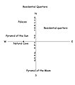 Teotihuacancityplan.jpg 997 × 1,131; 142 KB
-
 Teotihuacancityplan.png 512 × 384; 13 KB
-
 Teotihuacans monumentalbyggnader utlagda på karta över Stockholm - SMVK - 0307.a.0001.tif 3,795 × 3,763; 103.37 MB
-
 Teotihucan layout.gif 338 × 629; 18 KB
-

-

.jpg)
.jpg)
.jpg)


.jpg)


_(14596245669).jpg)
_(14596407377).jpg)