Category:Maps of Tangipahoa Parish, Louisiana
Appearance
Parishes of Louisiana: Acadia · Allen · Ascension · Assumption · Avoyelles · Beauregard · Bienville · Bossier · Caddo · Calcasieu · Caldwell · Cameron · Catahoula · Claiborne · Concordia · DeSoto · East Baton Rouge · East Carroll · East Feliciana · Evangeline · Franklin · Grant · Iberia · Iberville · Jackson · Jefferson · Jefferson Davis · Lafayette · Lafourche · LaSalle · Lincoln · Livingston · Madison · Morehouse · Natchitoches · Orleans · Ouachita · Plaquemines · Pointe Coupee · Rapides · Red River · Richland · Sabine · Saint Bernard · Saint Charles · Saint Helena · Saint James · Saint John the Baptist · Saint Landry · Saint Martin · Saint Mary · Saint Tammany · Tangipahoa · Tensas · Terrebonne · Union · Vermilion · Vernon · Washington · Webster · West Baton Rouge · West Carroll · West Feliciana · Winn
Wikimedia category | |||||
| Upload media | |||||
| Instance of | |||||
|---|---|---|---|---|---|
| Category combines topics | |||||
| Tangipahoa Parish | |||||
parish in Louisiana, United States | |||||
| Instance of | |||||
| Named after |
| ||||
| Location | Louisiana | ||||
| Capital | |||||
| Inception |
| ||||
| Population |
| ||||
| Area |
| ||||
| Elevation above sea level |
| ||||
| official website | |||||
 | |||||
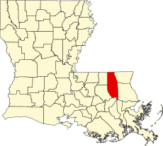
Tangipahoa Parish is located in Louisiana in the United States. Its parish seat is Amite City.
Media in category "Maps of Tangipahoa Parish, Louisiana"
The following 30 files are in this category, out of 30 total.
-
Baton Rouge–Hammond combined statistical area.svg 5,018 × 4,515; 550 KB
-
February 8 tornado track.png 1,046 × 886; 903 KB
-
LA-districts-109-01.gif 635 × 379; 33 KB
-
LAMap-doton-Amite City.png 300 × 275; 12 KB
-
LAMap-doton-Independence.png 300 × 275; 12 KB
-
LAMap-doton-Kentwood.png 300 × 275; 12 KB
-
LAMap-doton-Natalbany.png 300 × 275; 12 KB
-
LAMap-doton-Roseland.png 300 × 275; 12 KB
-
LAMap-doton-Tangipahoa.png 300 × 275; 12 KB
-
LAMap-doton-Tickfaw.png 300 × 275; 12 KB
-
Louisiana Senate District 11 (2010).png 3,165 × 2,781; 991 KB
-
Louisiana Senate District 12 (2010).png 3,165 × 2,781; 990 KB
-
Louisiana Senate District 13 (2010).png 3,165 × 2,781; 990 KB
-
Louisiana Senate District 6 (2010).png 3,165 × 2,781; 995 KB
-
Map of Louisiana highlighting Tangipahoa Parish.svg 1,255 × 1,129; 169 KB
-
Map of Tangipahoa Parish Louisiana With Municipal Labels.PNG 297 × 819; 32 KB
-
New Orleans–Metairie–Hammond combined statistical area.svg 997 × 1,200; 1.08 MB
-
Tangipahoa Parish Louisiana Map 1935 Ponchatoula Pass Manchac.jpg 2,363 × 2,786; 1.92 MB
-
Tangipahoa Parish Louisiana.png 300 × 275; 14 KB


