Category:Maps of Tacna-Arica dispute
Jump to navigation
Jump to search
Media in category "Maps of Tacna-Arica dispute"
The following 12 files are in this category, out of 12 total.
-
 Borders Chile 1879 and 2006 SP.png 363 × 526; 9 KB
-

-
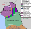
 Cuestión de Tacna y Arica.png 4,213 × 4,090; 922 KB
-
 Cuestión de Tacna y Arica.svg 3,954 × 3,837; 1.03 MB
-
 Departamento de Arica, Chile.svg 3,093 × 2,937; 787 KB
-
 Mapa del Perú (1913).jpg 7,205 × 10,484; 10.65 MB
-
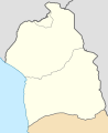
 Provincia de Tacna, Chile (1884-1925).svg 2,268 × 2,764; 285 KB
-
 Provincia de Tacna, Chile (1925-1929).svg 2,268 × 2,764; 252 KB
-
 Tacna province (1884-1925) Chile location map.svg 2,268 × 2,764; 146 KB
-
 Tacna province (1925-1929) Chile location map.svg 2,268 × 2,764; 80 KB
-
 Tacna-Arica Dispute (1883-1929).svg 3,954 × 3,837; 1 MB
-
 Territorial losses of the Republic of Chile de jure.svg 1,800 × 2,808; 3.75 MB


.jpg)
.svg)
.svg)
_Chile_location_map.svg)
_Chile_location_map.svg)
.svg)
