Category:Maps of Stutsman County, North Dakota
Jump to navigation
Jump to search
Wikimedia category | |||||
| Upload media | |||||
| Instance of | |||||
|---|---|---|---|---|---|
| Category combines topics | |||||
| Stutsman County | |||||
county in North Dakota, United States   | |||||
| Instance of | |||||
| Named after |
| ||||
| Location | North Dakota | ||||
| Capital | |||||
| Inception |
| ||||
| Population |
| ||||
| Area |
| ||||
| official website | |||||
 | |||||
Media in category "Maps of Stutsman County, North Dakota"
The following 19 files are in this category, out of 19 total.
-
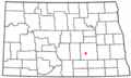
 Map of North Dakota highlighting Stutsman County.svg 1,935 × 1,152; 41 KB
-
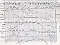
 Map of Stutsman County, N.D., 1911.jpg 5,420 × 5,208; 28.01 MB
-
 Military Reservation of Fort Seward.png 1,415 × 2,409; 3.32 MB
-
-
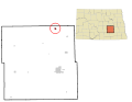
 ND Stutsman County Buchanan.svg 990 × 765; 421 KB
-
 ND Stutsman County Cleveland.svg 990 × 765; 421 KB
-
 ND Stutsman County Courtenay.svg 990 × 765; 421 KB
-
 ND Stutsman County Jamestown.svg 990 × 765; 421 KB
-
 ND Stutsman County Kensal.svg 990 × 765; 421 KB
-
 ND Stutsman County Medina.svg 990 × 765; 421 KB
-
 ND Stutsman County Montpelier.svg 990 × 765; 421 KB
-
 ND Stutsman County Pingree.svg 990 × 765; 421 KB
-
 ND Stutsman County Spiritwood Lake.svg 990 × 765; 422 KB
-
 ND Stutsman County Streeter.svg 990 × 765; 421 KB
-
 ND Stutsman County Woodworth.svg 990 × 765; 421 KB
-
 NDMap-doton-Buchanan.PNG 300 × 179; 11 KB
-
 NDMap-doton-Cleveland.PNG 300 × 179; 11 KB
-
 NDMap-doton-Jamestown.PNG 300 × 179; 11 KB
-
 NDMap-doton-Woodworth.PNG 300 × 179; 11 KB


_(14586474787).jpg)


