<nowiki>Category:Maps of Stargard; categoría de Wikimedia; kategori Wikimedia; Wikimedia category; د ويکيمېډيا وېشنيزه; Vikimedya kategorisi; ویکیمیڈیا زمرہ; kategória projektov Wikimedia; категорія проєкту Вікімедіа; 维基媒体分类; Wikimedia-Kategorie; Викимедиина категорија; kategorija na Wikimediji; विकिपीडिया:श्रेणी; page de catégorie de Wikimedia; kategorija na Wikimediji; विकिपीडिया वर्ग; категорија на Викимедији; Wikimedia-Kategorie; Wikimedia-kategori; kategori Wikimédia; تصنيف ويكيميديا; pajenn rummata eus Wikimedia; Wikimedia:ကဏ္ဍခွဲခြင်း; 維基媒體分類; Wikimedia категориясы; categoría de Wikimedia; Wikimedia-Kategorie; Викимедиа категорияһы; tudalen categori Wikimedia; Viciméid catagóir; Վիքիմեդիայի նախագծի կատեգորիա; 维基媒体分类; Wikimedia-kategori; ვიკიპედია:კატეგორიზაცია; ウィキメディアのカテゴリ; categoria Wikimedia; تصنيف بتاع ويكيميديا; විකිමීඩියා ප්රභේද පිටුව; categoria Vicimediorum; विकिमीडिया श्रेणी; Wikimedia-luokka; Wikimedia category; guruhi Vikimedia; катэгорыя ў праекце Вікімэдыя; Викимедиа проектындагы төркем; catigurìa di nu pruggettu Wikimedia; หน้าหมวดหมู่วิกิมีเดีย; Wikimedia:Kategorija; Wikimedia-Kategorie; Wikimedia:Klassys; категория на Уикимедия; categorie a unui proiect Wikimedia; categurìa 'e nu pruggette Wikimedia; Wikimedia-kategori; kawan Wikimèdia; 維基媒體分類; 위키미디어 분류; Wikimedia-bólkur; kategorio en Vikimedio; kategori Wikimedia; Wikimedia:Ronnaghys; উইকিমিডিয়া বিষয়শ্রেণী; kategori Wikimedia; 维基媒体分类; וויקימעדיע קאַטעגאָריע; kategorija w projektach Wikimedije; thể loại Wikimedia; Wikimedia projekta kategorija; kategoria ti Wikimedia; categoria de um projeto da Wikimedia; Wikimedia category; категорияд Ангилал; Wikimedia-kategori; kategori Wikimedia; پۆلی ویکیمیدیا; Wikimedia category; Vikimédia ñemohenda; Wikimédia-kategória; વિકિપીડિયા શ્રેણી; Wikimediako kategoria; категория в проекте Викимедиа; Wikimedia-Kategorie; катэгорыя ў праекце Вікімедыя; Wikimedia-kategorie; Wîkîmediya:Kategorî; विकिमिडिया श्रेणी; Wikimedia-Kategorie; קטגוריה במיזמי ויקימדיה; Викимедиа проектындагы төркем; Wikimedia-categorie; विकिमिडिया श्रेणी; 维基媒体分类; Wikimedia-kategoriija; гурӯҳи Викимедиа; jamii ya Wikimedia; categoría de Wikimedia; Wikimedia-categorie; categoria di un progetto Wikimedia; Vikipidiya:Shopni; 维基媒体分类; 維基媒體分類; Wikimedia kategooria; Wikimedia-kategory; ردهٔ ویکیپدیا; kategorya ng Wikimedia; гурӯҳи Викимедиа; ẹ̀ka Wikimedia; kategorie na projektech Wikimedia; categoria de um projeto da Wikimedia; Wikimedia-Kategorie; Wikimedia-Kategorie; tumbung Wikimedia; Wikimedia-kategorie; kategorija Wikimedie; Wikimedia proyektındağı törkem; Wikimedia-categorie; விக்கிமீடியப் பகுப்பு; kategori Wikimedia; kategoria w projekcie Wikimedia; വിക്കിമീഡിയ വർഗ്ഗം; 維基媒體分類; kategori Wikimedia; categoria de Wikimedia; زمرو:وڪيپيڊيا زمرا بندي; Kategoriya ning Wikimedia; categoría de Wikimedia; kategori e Wikimedias; κατηγορία εγχειρημάτων Wikimedia; 維基媒體分類</nowiki>
Subcategories
This category has only the following subcategory.


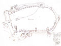 Fortyfikacje Stargardu.jpg 1,200 × 909; 159 KB
 Inoujście XV wiek-mapa.png 1,376 × 1,148; 79 KB
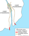 Inoujście1.PNG 1,220 × 1,493; 104 KB
 Mapa Powiatu Stargardzkiego.png 2,866 × 2,260; 1.97 MB
 Meyer‘s Zeitungsatlas 031 – Provinz Pommern.jpg 7,344 × 6,224; 17.16 MB
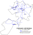 MZK Stargard mapa.svg 3,389 × 3,616; 107 KB
 POL Stargard Szczeciński map.svg 497 × 463; 47 KB
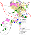 Stargard drogi.svg 930 × 1,048; 279 KB
 Stargard location map.png 1,324 × 1,270; 924 KB
 Stargard locaton map.jpg 848 × 781; 187 KB
 Stargard Mapa.PNG 491 × 454; 298 KB
 Stargard Mapa2.JPG 758 × 619; 680 KB
 Stargard plan miasta.svg 2,654 × 2,351; 4.23 MB
 Stargard Szczecinski Stare Miasto plan.svg 742 × 794; 482 KB
 Stargard Szczeciński-uklad komunikacyjny.jpg 1,000 × 1,188; 433 KB
 Stargardzki.png 756 × 594; 18 KB
 Bundesarchiv Bild 196-02656, Stargard.jpg 792 × 800; 125 KB


