<nowiki>Category:Maps of Stara Zagora; categoría de Wikimedia; kategori Wikimedia; Wikimedia category; د ويکيمېډيا وېشنيزه; Vikimedya kategorisi; ویکیمیڈیا زمرہ; kategória projektov Wikimedia; категорія проєкту Вікімедіа; 维基媒体分类; Wikimedia-Kategorie; Викимедиина категорија; kategorija na Wikimediji; विकिपीडिया:श्रेणी; page de catégorie de Wikimedia; kategorija na Wikimediji; विकिपीडिया वर्ग; категорија на Викимедији; Wikimedia-Kategorie; Wikimedia-kategori; kategori Wikimédia; تصنيف ويكيميديا; pajenn rummata eus Wikimedia; Wikimedia:ကဏ္ဍခွဲခြင်း; 維基媒體分類; Wikimedia категориясы; categoría de Wikimedia; Wikimedia-categorie; Викимедиа категорияһы; tudalen categori Wikimedia; kategori e Wikimedias; ردهٔ ویکیپدیا; 维基媒体分类; Wikimedia-kategory; ვიკიპედია:კატეგორიზაცია; ウィキメディアのカテゴリ; categoria Wikimedia; تصنيف بتاع ويكيميديا; විකිමීඩියා ප්රභේද පිටුව; categoria Vicimediorum; विकिमीडिया श्रेणी; Wikimedia-luokka; Wikimedia category; விக்கிமீடியப் பகுப்பு; катэгорыя ў праекце Вікімэдыя; Викимедиа проектындагы төркем; catigurìa di nu pruggettu Wikimedia; หน้าหมวดหมู่วิกิมีเดีย; Wikimedia:Kategorija; Wikimedia-Kategorie; Wikimedia:Klassys; категория на Уикимедия; categorie a unui proiect Wikimedia; categurìa 'e nu pruggette Wikimedia; Wikimedia-kategori; kawan Wikimèdia; 維基媒體分類; 위키미디어 분류; Wikimedia-bólkur; kategorio en Vikimedio; kategori Wikimedia; Wikimedia:Ronnaghys; উইকিমিডিয়া বিষয়শ্রেণী; kategori Wikimedia; 维基媒体分类; וויקימעדיע קאַטעגאָריע; kategorija w projektach Wikimedije; thể loại Wikimedia; Wikimedia projekta kategorija; kategoria ti Wikimedia; categoria de um projeto da Wikimedia; 维基媒体分类; категорияд Ангилал; Wikimedia-kategori; kategori Wikimedia; پۆلی ویکیمیدیا; Wikimedia category; Vikimédia ñemohenda; Wikimédia-kategória; વિકિપીડિયા શ્રેણી; Wikimediako kategoria; категория в проекте Викимедиа; Wikimedia-Kategorie; Kategoriya ning Wikimedia; Wikimedia-kategorie; Wîkîmediya:Kategorî; विकिमिडिया श्रेणी; Wikimedia-Kategorie; קטגוריה במיזמי ויקימדיה; Викимедиа проектындагы төркем; Wikimedia-categorie; विकिमिडिया श्रेणी; 维基媒体分类; Wikimedia-kategoriija; гурӯҳи Викимедиа; categoria de Wikimedia; categoría de Wikimedia; Viciméid catagóir; categoria di un progetto Wikimedia; Wikimedia category; kategoria w projekcie Wikimedia; катэгорыя ў праекце Вікімедыя; Wikimedia kategooria; 維基媒體分類; Wikimedia-kategori; Վիքիմեդիայի նախագծի կատեգորիա; Wikimedia proyektındağı törkem; ẹ̀ka Wikimedia; гурӯҳи Викимедиа; categoria de um projeto da Wikimedia; kategorie na projektech Wikimedia; Wikimedia-Kategorie; tumbung Wikimedia; Wikimedia-categorie; kategorija Wikimedie; kategorya ng Wikimedia; Wikimedia-kategorie; Wikimedia-Kategorie; kategori Wikimedia; jamii ya Wikimedia; വിക്കിമീഡിയ വർഗ്ഗം; 維基媒體分類; kategori Wikimedia; Vikipidiya:Shopni; زمرو:وڪيپيڊيا زمرا بندي; Wikimedia-Kategorie; categoría de Wikimedia; 維基媒體分類; κατηγορία εγχειρημάτων Wikimedia; guruhi Vikimedia</nowiki>
Subcategories
This category has only the following subcategory.


.svg)


 Aiazmoto1.JPG 640 × 480; 339 KB
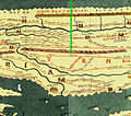 Berone Beroe StaraZagoraTabulaPeutingeriana.jpg 764 × 674; 223 KB
 Boruy Fortress plan.png 2,243 × 1,671; 402 KB
 Kazanka-area.maps01.jpg 1,926 × 1,527; 1.87 MB
 P B STARA ZAGORA 1879 COPY.jpg 1,716 × 1,259; 2.62 MB
 Stara Zagora location in Bulgaria.png 202 × 134; 2 KB
 Stara Zagora uprising.png 1,149 × 1,172; 276 KB
 Stara Zagora, 1879 rebuild plan.jpg 3,713 × 2,723; 2.54 MB
 StaraSagora NovaSagora Bulgaria 1994 CIA map.jpg 400 × 400; 59 KB
 StaraZagora-districts-en.svg 3,000 × 2,300; 65 KB
 StaraZagora-districts.svg 3,000 × 2,300; 65 KB
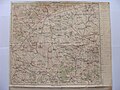 Topographic map Stara Zagora 1941.jpg 3,264 × 2,448; 2.8 MB
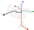 Trolleybus network - Stara Zagora (Bulgaria).svg 566 × 499; 19 KB
 Ulpia Augusta Traiana - bg.svg 996 × 801; 887 KB
 Ulpia Augusta Traiana - en.svg 996 × 801; 973 KB


.svg)

