Category:Maps of St Austell
Jump to navigation
Jump to search
Media in category "Maps of St Austell"
The following 10 files are in this category, out of 10 total.
-
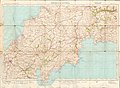 Ordnance Survey One-Inch Sheet 143 Truro & St Austell, Published 1918r.jpg 13,983 × 10,219; 13.81 MB
-
 Ordnance Survey One-Inch Sheet 143 Truro, Published 1918.jpg 13,991 × 10,267; 13.97 MB
-
 Ordnance Survey One-Inch Sheet 185 Newquay & Padstow, Published 1946.jpg 8,199 × 9,557; 7.83 MB
-
 Ordnance Survey One-Inch Sheet 185 Newquay & Padstow, Published 1961.jpg 8,262 × 9,926; 7.99 MB
-
 Ordnance Survey One-Inch Sheet 185 Newquay & Padstow, Published 1972.jpg 11,063 × 13,251; 39.16 MB
-
 Ordnance Survey One-Inch Sheet 190 Truro & Falmouth, Published 1961.jpg 8,198 × 9,967; 8.49 MB
-
 Ordnance Survey One-Inch Sheet 190 Truro & Falmouth, Published 1972.jpg 11,099 × 13,145; 39.33 MB
-
 Ordnance Survey One-Inch Sheet 190 Truro and Falmouth, Published 1946.jpg 8,186 × 9,581; 8.52 MB
-
 St Austell - Cornwall dot.png 417 × 599; 122 KB
-
 StAustellCornwallNewParishes.gif 839 × 1,200; 42 KB


