Category:Maps of Somerville, Massachusetts
Jump to navigation
Jump to search
Wikimedia category | |||||
| Upload media | |||||
| Instance of | |||||
|---|---|---|---|---|---|
| Category combines topics | |||||
| Somerville | |||||
city in Middlesex County, Massachusetts, United States    | |||||
| Instance of | |||||
| Part of |
| ||||
| Location | Middlesex County, Massachusetts | ||||
| Inception |
| ||||
| Population |
| ||||
| Area |
| ||||
| Elevation above sea level |
| ||||
| official website | |||||
 | |||||
Subcategories
This category has the following 4 subcategories, out of 4 total.
Media in category "Maps of Somerville, Massachusetts"
The following 30 files are in this category, out of 30 total.
-
 1852 map Somerville Massachusetts byDraper BPL10528.png 1,061 × 746; 1.22 MB
-

-
 1884 map wards Somerville Massachusetts USA BPL12900.png 1,144 × 652; 1.22 MB
-
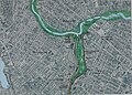
 Alewife Reservation and Alewife Brook master plan (2003) (17327107974).jpg 3,910 × 2,954; 3.72 MB
-
 Alewife Reservation and Alewife Brook master plan (2003) (17327115894).jpg 4,092 × 2,944; 3.64 MB
-
 Annual report of the city of Somerville (1894) (14595929579).jpg 5,284 × 2,694; 3.2 MB
-

-
 Boston 1775.jpg 797 × 776; 250 KB
-
 Davis square flattened.jpg 2,202 × 2,130; 915 KB
-
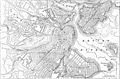 EB9 Boston.jpg 2,559 × 1,681; 961 KB
-
 Fitchburg Cutoff modern status map.svg 1,850 × 1,150; 39 KB
-
 Fitchburg Cutoff rail map.svg 1,850 × 1,150; 45 KB
-
 Map of Somerville, Mass. (2674605704).jpg 2,000 × 1,343; 2.07 MB
-
 Map of the city of Somerville 1884 (7557370976).jpg 8,514 × 5,114; 40.74 MB
-
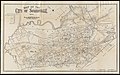 Map of the city of Somerville 1895 (9138250914).jpg 800 × 499; 109 KB
-
 Map of the city of Somerville, 1907 (9144002178).jpg 800 × 418; 97 KB
-
-

-
 Plan of real estate in Charlestown, showing park laid out (3856497224).jpg 2,000 × 1,422; 2.22 MB
-

-

-
 Somerville ma highlight.png 788 × 466; 55 KB
-
 Ward 1 by precinct.png 1,170 × 958; 84 KB
-
 Ward 2 by precinct.png 1,170 × 958; 80 KB
-
 Ward 5 by precinct.png 1,170 × 958; 78 KB
-
 Ward 6 by precinct.png 1,170 × 958; 77 KB
-
 Ward 7 by precinct.png 1,170 × 958; 79 KB
-
 Ward2.png 1,200 × 1,014; 80 KB
-
 Ward4.png 1,210 × 1,010; 81 KB
-
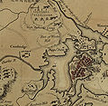
 WinterHillLOCmap.jpg 1,138 × 674; 204 KB


_(17327107974).jpg)
_(17327115894).jpg)
_(14595929579).jpg)


.jpg)
.jpg)
.jpg)
.jpg)


.jpg)


