Category:Maps of Soissons
Jump to navigation
Jump to search
Wikimedia category | |||||
| Upload media | |||||
| Instance of | |||||
|---|---|---|---|---|---|
| Category combines topics | |||||
| Soissons | |||||
commune in Aisne, France  .svg) | |||||
| Instance of | |||||
| Location |
| ||||
| Located in or next to body of water | |||||
| Head of government |
| ||||
| Significant event |
| ||||
| Population |
| ||||
| Area |
| ||||
| Elevation above sea level |
| ||||
| official website | |||||
 | |||||
Subcategories
This category has the following 2 subcategories, out of 2 total.
A
- Attraction maps of Soissons (2 F)
Media in category "Maps of Soissons"
The following 6 files are in this category, out of 6 total.
-
 02 AISNE carte grille communale densite INSEE.png 3,507 × 2,480; 4.93 MB
-
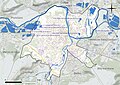 02722-Soissons-Hydro.jpeg 5,846 × 4,133; 3.29 MB
-
 02722-Soissons-Sols.png 3,270 × 2,598; 4.65 MB
-
 Diocèse Soissons 1789.svg 2,000 × 1,922; 801 KB
-
 Environs de Soissons - btv1b8446091v.jpg 10,654 × 7,968; 14.01 MB
-
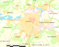 Map commune FR insee code 02722.png 756 × 605; 63 KB


