Category:Maps of Shikoku
Jump to navigation
Jump to search
Wikimedia category | |||||
| Upload media | |||||
| Instance of | |||||
|---|---|---|---|---|---|
| Category combines topics | |||||
| Shikoku | |||||
fourth largest island of Japan     | |||||
| Instance of | |||||
| Part of |
| ||||
| Location | Shikoku Region, Japan | ||||
| Located in or next to body of water | |||||
| Length |
| ||||
| Highest point |
| ||||
| Population |
| ||||
| Area |
| ||||
| Elevation above sea level |
| ||||
| Said to be the same as | Shikoku Region | ||||
 | |||||
Media in category "Maps of Shikoku"
The following 28 files are in this category, out of 28 total.
-
-
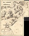
 Admiralty Chart No 951 Muroto Saki to Miki Saki, Published 1937.jpg 18,410 × 11,283; 65.97 MB
-
 Eight regions of japan7 shikoku.png 500 × 300; 17 KB
-
 Geofeatures map of Shikoku Japan ja.svg 1,246 × 960; 2.95 MB
-

-
 Japan Chūshikoku Region large.png 1,397 × 1,593; 89 KB
-
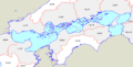
 Japan first class rivers Shikoku map.svg 291 × 207; 83 KB
-
 Japan Setouchi Region large.png 1,397 × 1,593; 89 KB
-
 Japan Shikoku Map Chikei.gif 931 × 538; 145 KB
-
 Japan shikoku map small.png 235 × 300; 22 KB
-
 Japan Shikoku Region large.png 1,397 × 1,593; 110 KB
-
 Japan Shikoku Region.png 345 × 213; 14 KB
-
 Kochi and Tokushima in Japan.svg 413 × 373; 950 KB
-
 Seto Inland Sea01.png 875 × 444; 15 KB
-
 Seto Inland Sea02.png 875 × 444; 15 KB
-
 Shikoku hrdist map 2003.PNG 550 × 400; 16 KB
-
 Shikoku Pilgrimage Map01.png 984 × 736; 124 KB
-
 Shikoku Region Administration Map TC.png 600 × 600; 43 KB
-
 Shikoku Region Administration Map-fa.jpg 600 × 600; 59 KB
-
 Shikoku Region in Japan (extended).svg 580 × 578; 1.58 MB
-
 Shikoku Region in Japan (narrow).svg 271 × 363; 1.71 MB
-
 Shikoku Region in Japan.svg 413 × 373; 601 KB
-
 Shikoku-Pilgerweg.svg 1,246 × 960; 3.43 MB
-
 Shikoku-region Small.png 199 × 228; 2 KB
-
 Sicocu-miti.png 900 × 650; 1.68 MB
-
 Карта Сикоку.png 1,279 × 869; 858 KB
-
 久万高原周辺.jpg 859 × 861; 324 KB
-
 四国本土最北端の説明図.jpg 4,896 × 3,672; 4.41 MB


.svg)
.svg)


