Category:Maps of Shalinsky District
Jump to navigation
Jump to search
Media in category "Maps of Shalinsky District"
The following 19 files are in this category, out of 19 total.
-
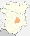
 Location Of Shalinsky District (Chechnya).svg 6,295 × 7,662; 1.13 MB
-
 Location Of Shalinsky District (Chechnya, 2009).svg 6,295 × 7,662; 1.13 MB
-
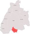
 Outline map of Shalinsky District on the map of Chechnya.png 1,518 × 1,686; 259 KB
-
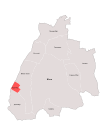
 Outline map of Shalinsky District on the map of Chechnya.svg 1,518 × 1,686; 1.29 MB
-
 АГЕШТЫ Карта.svg 2,590 × 2,980; 1.82 MB
-
 Карта г. ШАЛИ.svg 3,140 × 3,373; 1.82 MB
-

-
 Карта с. АВТУРЫ.svg 3,140 × 3,373; 1.82 MB
-
 Карта с. Агишты.svg 3,140 × 3,373; 1.82 MB
-
 Карта с. БЕЛГАТОЙ.svg 3,140 × 3,373; 1.82 MB
-
 Карта с. ГЕРМЕНЧУК.svg 3,140 × 3,373; 1.82 MB
-
 Карта с. ДУБА-ЮРТ.svg 3,140 × 3,373; 1.82 MB
-
 Карта с. МЕСКЕР-ЮРТ.svg 3,140 × 3,373; 1.82 MB
-
 Карта с. Новые Атаги.svg 3,140 × 3,373; 1.82 MB
-
 Карта с. СЕРЖЕНЬ-ЮРТ.svg 3,140 × 3,373; 1.82 MB
-
 Карта с. ЧИРИ-ЮРТ.svg 3,140 × 3,373; 1.82 MB
-
 Карта Шалинского района.svg 1,024 × 1,166; 107 KB
-
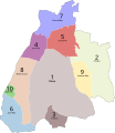 Пронумерованная карта Шалинского Района.svg 2,564 × 2,953; 3.54 MB
-
 Чартой-юрт.jpg 960 × 720; 145 KB
.svg)
.svg)


.jpg)


