Category:Maps of Savannah, Georgia
Jump to navigation
Jump to search
Subcategories
This category has only the following subcategory.
Media in category "Maps of Savannah, Georgia"
The following 23 files are in this category, out of 23 total.
-
 Coltons plans of U.S. harbors (Savannah).jpg 466 × 283; 186 KB
-

-
 496 of 'History of the American Civil War, etc' (11059553765).jpg 936 × 707; 160 KB
-
 GAMap-doton-Savannah 200px.PNG 200 × 233; 35 KB
-
 GAMap-doton-Savannah.png 284 × 330; 47 KB
-
 Map of the city of Savannah and vicinity (10842796005).jpg 800 × 456; 83 KB
-

-

-
 Race and ethnicity 2010- Savannah (5559843151).png 3,009 × 3,009; 1.73 MB
-
 Savannah Aldermanic Districts.jpg 4,224 × 3,264; 2.56 MB
-
 Savannah city 1910.jpg 1,882 × 1,418; 279 KB
-
 Savannah cityplan 1818.jpg 1,875 × 1,440; 896 KB
-
 Savannah Neighborhoods.jpg 4,224 × 3,264; 3.52 MB
-
 Savannah On Map.png 433 × 369; 11 KB
-
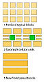 Savannah Portland NewYork City Blocks FG.jpg 324 × 591; 73 KB
-
 Savannah Portland NewYork City Blocks.svg 325 × 575; 3 KB
-
 Savannah printable tourist attractions map.jpg 2,105 × 1,488; 1.55 MB
-
 Savannah Union Station Company - System Index Map.jpg 3,292 × 5,100; 2.99 MB
-
 Savannah, 1779 RCIN 734052.jpg 2,000 × 1,574; 1.08 MB
-
 Savannah, GA.png 1,282 × 802; 359 KB
-
 SavannahCityPlan1770.jpg 600 × 400; 219 KB
-
 SCMPD Precincts.jpg 4,224 × 3,264; 2.23 MB
-
 Siege ville de Savannah 1779.jpg 2,049 × 1,415; 421 KB
.jpg)
%27_(11253107916).jpg)
.jpg)


.jpg)

.png)


