Category:Maps of Sainte-Thorette
Jump to navigation
Jump to search
Wikimedia category | |||||
| Upload media | |||||
| Instance of | |||||
|---|---|---|---|---|---|
| Category combines topics | |||||
| Sainte-Thorette | |||||
commune in Cher, France   | |||||
| Instance of | |||||
| Location |
| ||||
| Located in or next to body of water | |||||
| Population |
| ||||
| Area |
| ||||
| official website | |||||
 | |||||
Media in category "Maps of Sainte-Thorette"
The following 2 files are in this category, out of 2 total.
-
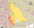 18237-Sainte-Thorette-argile.png 3,057 × 2,480; 2.76 MB
-
 18237-Sainte-Thorette-Hydro.jpeg 5,846 × 4,133; 1.95 MB

