Category:Maps of Rotterdam by Berckenrode
Jump to navigation
Jump to search
Media in category "Maps of Rotterdam by Berckenrode"
The following 21 files are in this category, out of 21 total.
-
 Rotterdam - btv1b53212658p (1 of 2).jpg 11,369 × 9,557; 28.4 MB
-
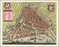
 Map of Rotterdam by Joan Blaeu 1649.jpg 5,500 × 4,471; 4.2 MB
-

-
 Rotterdam 1649 Blaeu'.jpg 1,980 × 1,570; 842 KB
-
 Blaeu 1652 - Rotterdam.jpg 1,980 × 1,570; 842 KB
-
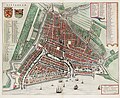
 Atlas Van der Hagen-KW1049B11 087-TABULA ROTERODAMI NOVISSIMA.jpeg 5,500 × 4,596; 5.63 MB
-
-
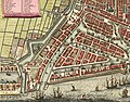
 Rotterdam Map by Frederick De Wit c1690.jpg 11,266 × 9,002; 23.71 MB
-
 1695 - Rotterdam by Johannes de Vou.JPG 3,182 × 2,865; 10.93 MB
-
 Plattegrond van Rotterdam door Johannes de Vou, objectnr 57280(1).JPG 7,057 × 5,916; 38.88 MB
-
 Rotterdam - De Vou+ De Hooghe, 1694.jpg 2,596 × 2,346; 1.67 MB
-
 Atlas de Wit 1698-pl020-Rotterdam-KB PPN 145205088.jpg 2,000 × 1,662; 1.94 MB
-
 Rotterdam - (M. Merian) - btv1b53225501f (1 of 2).jpg 4,157 × 3,353; 4.47 MB
-
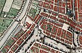
 Blaak, Kolk, Oude Haven, Laurenskerk in Rotterdam Map Detail by Frederick De Wit c1690.jpg 3,000 × 3,151; 2.84 MB
-
 Coolsingel met Binnenwegse of Koolseweg poort, 1649.jpg 1,893 × 1,214; 693 KB
-
 Haringvliet, Oude Haven, Nieuwe Haven, Blaeck in Rotterdam Map by Frederick De Wit c1690.jpg 5,976 × 4,328; 7.16 MB
-
 Kaart Haringvliet Rotterdam.jpg 713 × 418; 320 KB
-
 Oud-Nederlandsche steden in haar ontstaan, groei en ontwikkeling (1909) (14764972982).jpg 2,864 × 2,388; 1.29 MB
-
 Rotterdam Kolk 1626 1652.jpg 900 × 625; 256 KB
-
 Rotterdam Kolk 1626.jpg 450 × 625; 119 KB
-
 Rotterdam Kolk 1652.jpg 450 × 625; 139 KB
.jpg)


.JPG)


_-_btv1b53225501f_(1_of_2).jpg)


_(14764972982).jpg)


