Category:Maps of Romania in World War II
Jump to navigation
Jump to search
Wikimedia category | |||||
| Upload media | |||||
| Instance of | |||||
|---|---|---|---|---|---|
| Category combines topics | |||||
| Romania in World War II | |||||
involvement of Romania in World War II | |||||
| Instance of | |||||
| Part of | |||||
| Facet of | |||||
| Location |
| ||||
| |||||
Subcategories
This category has the following 2 subcategories, out of 2 total.
M
- Maps of Northern Transylvania (34 F)
S
- South German Buffer State (5 F)
Media in category "Maps of Romania in World War II"
The following 62 files are in this category, out of 62 total.
-
 AtlBalk1940.jpg 318 × 327; 146 KB
-
 AtlBalk1942.jpg 318 × 327; 141 KB
-
 BagrationMap2.jpg 1,256 × 956; 1.05 MB
-
 Balkanfront 19440831-19441130.png 530 × 617; 763 KB
-
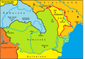
 Bucovina division es.svg 1,003 × 1,189; 336 KB
-
 Bucovina division.svg 820 × 1,065; 395 KB
-
 CampañaRumana1944.svg 2,609 × 2,000; 1,016 KB
-
 CRO RO SVK.png 450 × 456; 66 KB
-
 Desfasurare 23 August 1944.jpg 2,517 × 1,925; 770 KB
-
 Die deutschen Siedlungen in Südsiebenbürgen (1940).jpg 6,964 × 4,803; 2.82 MB
-
 Eastern Front 1943-08 to 1944-12 de.png 1,201 × 921; 360 KB
-
 Eastern Front 1943-08 to 1944-12.png 1,201 × 921; 290 KB
-
 Gebietsveränderungen Balkan 1938-43.png 387 × 617; 298 KB
-
 GUVERNAMANTUL BASARABIEI.png 1,905 × 2,457; 758 KB
-
 GUVERNAMANTUL BUCOVINEI.png 1,377 × 1,211; 387 KB
-
 Jassy–Kishinev Offensive (August 1944) map es.svg 1,228 × 1,020; 527 KB
-
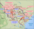 Jassy–Kishinev Offensive (August 1944) map ru.svg 1,228 × 1,020; 1.29 MB
-
 Karte Raffinerien von Ploiesti.png 1,060 × 803; 313 KB
-
 Kingdom of Romania (1942).svg 450 × 456; 482 KB
-
 Kvadriláter.jpg 277 × 300; 12 KB
-
 Moldavian SSR in March–August 1944.svg 477 × 499; 339 KB
-
 MSSR 1940.png 819 × 573; 62 KB
-
 Northern Transylvania yellow.png 471 × 371; 7 KB
-
 PerdidasTerritorialesRumanas1940 de.svg 1,057 × 742; 154 KB
-
 PérdidasTerritorialesRumanas1940-hu.svg 1,036 × 742; 180 KB
-
 PérdidasTerritorialesRumanas1940-ro.svg 1,036 × 742; 179 KB
-
 PérdidasTerritorialesRumanas1940.svg 1,036 × 742; 328 KB
-
 Rep. Moldova Iulie 1940.jpg 527 × 593; 432 KB
-
 Rom1940-1941.png 587 × 430; 30 KB
-
 Rom1942-HE.png 646 × 475; 22 KB
-
 Rom1942.jpg 648 × 480; 343 KB
-
 Rom1942.png 1,060 × 780; 157 KB
-
 Romania 1940 1941 be.svg 1,036 × 742; 246 KB
-
 Romania 1940 1941 es.svg 1,036 × 742; 318 KB
-
 Romania 1940 1941 mk.svg 1,036 × 742; 259 KB
-
 Romania 1940 1941 ro.svg 1,036 × 742; 238 KB
-
 Romania 1940 1941 ru.svg 1,036 × 742; 521 KB
-
 Romania 1940 1941-hu.svg 1,036 × 742; 238 KB
-
 Romania 1942 de.svg 1,060 × 780; 172 KB
-
 Romania 1942 es.svg 1,060 × 780; 352 KB
-
 Romania 1942 mk.svg 1,060 × 780; 261 KB
-
 Romania 1942 no.svg 1,060 × 780; 261 KB
-
 Romania 1942 ru.svg 1,060 × 780; 588 KB
-
 ROMANIA MAI 1942.png 4,263 × 2,931; 3.43 MB
-
 Romania wwII-de cropped.jpg 707 × 557; 148 KB
-
 Romania wwII-de.svg 471 × 371; 25 KB
-
 Romania wwII-hu.svg 471 × 371; 27 KB
-
 Romania wwII-ro.svg 471 × 371; 25 KB
-
 Romania wwII.svg 471 × 371; 26 KB
-
 Romania's 1940 lost territories.jpg 300 × 245; 35 KB
-
 Romania1941.png 950 × 700; 60 KB
-
 Tinuturi Romania septembrie 1940.svg 1,744 × 1,270; 1.02 MB
-
 Transnistria administratie romaneasca.png 393 × 708; 11 KB
-
 Transnistria WW2.svg 1,300 × 3,200; 2.26 MB
-
 Uman–Botoșani Offensive (Уманско-Ботошанская операция).svg 567 × 595; 359 KB
-
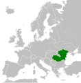
 WorldWarIILocationMapRO.png 630 × 766; 23 KB
-
 WWII administrative map of Romania.svg 5,954 × 4,093; 4.41 MB
-
 WWII Southern Central Europe 1944-1945-es.svg 2,001 × 1,415; 1.2 MB
-
 WWII Southern Central Europe 1944-1945-pt.svg 2,001 × 1,415; 835 KB
-
 WWII Southern Central Europe 1944-1945.png 2,000 × 1,415; 162 KB
-
 WWII Southern Central Europe 1944-1945.svg 2,001 × 1,415; 1.56 MB
-
 Ясско-Кишинёвская операция.jpg 1,188 × 1,827; 296 KB


.jpg)


_map_es.svg)
_map_ru.svg)

.svg)


.svg)


